Pages

Monday, August 29, 2016

Ambridge memorabilia: Armco "Iron Man" keychain, 1969

In 1969, the Ambridge Works, Armco Steel Corp., won Armco's Iron Man award for outstanding safety. According to the Jan. 28, 1970, Beaver County Times, the Ambridge Works beat out Butler PA, Baltimore MD, Houston TX, and Ashland KY plants for the award.

The award was presented at a Feb. 5, 1970, ceremony at the plant. I'm guessing the keychain in these photos was distributed to employees to mark their achievement.


Iron Man Award Keychain
Armco Ambridge Works
1969
Side 1


Iron Man Award Keychain
Armco Ambridge Works
1969
Side 2

According to the Times article: "The Armco Iron Man contest began in 1925....The Ambridge Works became eligible to compete in 1962." In that first year, the Ambridge plant ranked last.

At the time of the award, the plant employed about 1,700 workers. When it closed in 1985, 1,200 employees lost their jobs. The plant's former site is now the location of the Ambridge Regional Distribution and Manufacturing Center.

Saturday, August 27, 2016

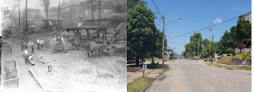
Street work, Duss Ave. and Fifth St., 1920s

This photo shows street work near the intersection of Duss Ave. and Fifth St., between 1919 and 1928 as I can best determine right now.

Road work
Duss Ave. near Fifth St.
circa 1919 - 1928
courtesy Borough of Ambridge

The large building on top of the hill on the right side of the photo was Harmony School,* built in 1912 and razed in 1965, now the site of the Ambridge Tower Apartments for seniors.

Harmony School
5th St. and Duss Ave.
Daily Times supplement, August 10, 1929?
Louis Vukovcan collection
courtesy of Jackie Vukovcan

The date the Borough had for this photo was "the 1930s"; however, Maria Notarianni noted that the photo must be earlier than that, since the large St. Stanislaus Church** on the corner of Beaver Rd. and Sixth St., built in 1928, isn't in the photo. However, the 1919 building that was both school and church before the 1928 church was built, is in the photo. (To the left of Harmony School, there are a few homes, and then the St. Stanislaus school/church building. Beaver Rd. intersects with Duss Ave. where those homes are.) After the church had its own building, the building in the photo served as the St. Stanislaus School.

St. Stanislaus School
Beaver Rd.
Daily Times supplement, August 10, 1929?
Louis Vukovcan collection
courtesy of Jackie Vukovcan

I don't know what the Duss Ave. project was, but there are two good candidates: Maria found that the borough planned to grade Fifth Street "from Duss Avenue to Beaver Road" in September 1924. A second possibility is that in 1927, Ambridge and the state were discussing a paving project. The state would take over Duss Ave. as "a part of the route from the Allegheny County line to Rochester," and share in the cost of the paving. (Daily Times, April 28, 1927)

P. J. Shotter took a great photo of what the intersection looked like in July 2016:

Then and Now
Duss Ave. at Fifth St.
courtesy P. J. Shotter
July 2016

* Later used by St. Veronica High School.
** Now New Hope Community Church.

Tuesday, August 23, 2016

American Bridge and Ohio River postcard, 1920s

This postcard shows a drawing of American Bridge Co. from the Ohio River.

Every early colored postcard I've seen showing the Ohio River near Ambridge shows the river colored a pretty blue. Artistic license.

Note the green, undeveloped hills rising above still-growing Ambridge.

"American Bridge Co., Works"
postcard
postmarked 192?

reverse of above postcard
"Published by S. G. Horlick"

I can't make out the year the postcard was mailed. 192(something).

I also don't know what language the card's message is in. German? If anyone knows and can translate, please leave a comment.

You can see another, slightly later, postcard showing American Bridge and a lovely blue Ohio River in the February 4, 2015, post "Bird's-Eye View of Ambridge and American Bridge."

Tuesday, August 16, 2016

Lover's Lane becomes muddy Fourteenth St.

When Ambridge was still Economy, owned by the Harmony Society, a path existed on what is now 14th St. between the current Duss Ave. and Beaver Rd.

The path was lovely and tree-lined, first with the mulberry trees the Harmonists used for their silk-making, and later, apple trees. While it was formally called Mulberry Lane, then Apple Lane, it was popularly known as Lover's Lane. The Harmonists may have practiced celibacy, but that apparently didn't stop young people from romantic strolls.

Lover's Lane, Economy, PA
State Library of Pennsylvania
Old Economy Village archives

"Lover's Lane" was so beloved that a number of early postcard views of it were published.

Lover's Lane, Economy, Pa.
postcard
postmarked January 22, 1909

But that sylvan scene ended with the development of Ambridge. According to a December 26, 1916, Daily Times article, after the Liberty Land Company opened Apple Lane as a street in 1903, "the old apple trees began to decay and become scraggy. Now they are nearly all dead."

The photo below shows 14th St. after some houses were built on the former Lover's Lane, and utility poles were up, but the street was unpaved, and at the time of the photo, covered with rutted mud. Only a few straggly trees remained, near the top of the street. Above current Beaver Rd., the hill, then a part of Harmony Township, was still bare except for some trees.

The shot was taken looking east, from just above Duss Ave. The building in the right foreground appears to be the 14th St. side of the building on the southeast corner of 14th and Duss, before a rear addition was added. That building, 1398 Duss Ave., was built in 1914 according to Beaver Co. tax records.

Fourteenth St.
looking east from just above Duss Ave.
circa 1914 - 1920
John Dunn Collection

While I didn't look at the tax records for every house I could see in the photo, the records of the houses I did look up show they were built between 1906 and 1920.

Today, the street is paved with bricks, and trees again line the street, although not mulberry or apple trees.

Fourteenth St. looking east from Duss Ave.
April 16, 2016

You can read more about Economy's Lover's Lane in my February 14, 2014, blog post.

Saturday, August 13, 2016

Ambridge Library in Ambridge Hotel, 1925

Before Alexander Laughlin, Sr., the owner of Ambridge's Central Tube Company, built the magnificent Laughlin Memorial Library as a tribute to his late son, Alexander Laughlin, Jr., the Ambridge Woman's Club had established reading rooms to serve the community.

The first reading room was at 462 Maplewood Ave., in a building that still stands, currently being used as a residence. As the number of books and borrowers grew, the space on Maplewood became too crowded. So in 1920, the library moved to space in the large Ambridge Hotel on the corner of 8th and Merchant Sts.

According to information furnished by the Borough of Ambridge, the photo below shows the interior of the library in the Ambridge Hotel in 1925.

Ambridge Library interior
Ambridge Hotel, 8th and Merchant Sts.
1925
courtesy Borough of Ambridge

Around 1928, members of the Woman's Club approached Laughlin, Sr., for a donation to help fund the reading room in the hotel. He did something better; he built and gave to Ambridge the impressive library building that stands on 11th St. between Maplewood Ave. and Church St.

Update: October 25, 2016:

In the Daily Citizen's 50th Anniversary edition, June 25, 1954, it reprinted this old news snippet from 1920:
The I.O.O.F. which recently purchased the Hotel Ambridge has offered to rent the bar room for a library room at $60 per month and the executive committee of the Woman's Club voted to accept.
I'd guess the bar room became available after prohibition began in January 1920.