Showing posts with label postcard. Show all posts

Saturday, December 17, 2022

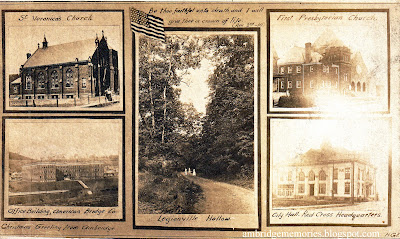
Vintage Ambridge Christmas postcard, circa 1918

"Christmas Greeting From Ambridge"
unposted vintage postcard
circa 1918
personal collection

In the left bottom corner of this card it says, "Christmas Greeting from Ambridge."

Shown on the card with photos' captions:

Left, top: St. Veronica's Church; bottom: Office Building American Bridge Co.

Right, top: First Presbyterian Church; bottom: City Hall, Red Cross Headquarters

Center: Legionville Hollow

Because the other four photos show notable Ambridge buildings, the choice of a scene showing three women strolling in a wooded Legionville Hollow lane as the larger center photo seems to me like an unusual choice. Maybe the scene held some special importance. Or maybe it was simply pretty. Or maybe it just fit better in the vertical space.

The American flag and bible verse at the top seem surprising for a Christmas card: "Be thou faithful unto death, and I will give thee a crown of life." (Rev. 2nd - 10). So merry. But I don't claim any expertise in vintage Christmas postcards, so maybe those are typical for the time.

This divided back postcard, now faded on the right side, was unmailed and had nothing written on the back. I based the "circa 1918" date, in part, on the photo of the First Presbyterian Church showing the church's "auditorium" that was dedicated in December 1917, after it was added to the right side of the earlier "chapel."

The flag, bible verse, and the "City Hall" (Ambridge's first Municipal Building) being described as the Red Cross Headquarters added to my thinking that this postcard might date from one of the U.S.'s WWI years (1917 - 1918), but I can't say with certainty. As do the dresses worn by the women in the Legionville Hollow photo.

Wednesday, March 31, 2021

Great St. Patrick's Day Flood, 1936: Ambridge stories


Unidentified boy looking at train on flooded railroad tracks,
east side of American Bridge Co., at the Ambridge Station 
St. Patrick's Day Flood, 1936
postcard
personal collection


The cause of the 1936 St. Patrick's Day floodthe biggest natural disaster in the history of the Pittsburgh regionhas been blamed on weeks of abnormal weather. First a prolonged cold spell allowed an unusual amount of snow and ice to accumulate. Then, just before St. Patrick's day, a sudden rise in temperature caused a rapid melt. And if those weren't problematic enough, an hours-long downpour added to the amount of water that had already been rising out of local streams and along the banks of Pittsburgh's rivers. Previously unimaginable destruction and death followed in Pittsburgh and many other river communities. 

During the overnight hours of March 17, the Ohio River began to rise in Ambridge. Although located along the river, Ambridge was relatively lucky thanks to its natural topography and to the American Bridge Company's occupation of most of the riverfront. American Bridge, though, wasn't so lucky.

The "crackerbox" tenements that had once stood on the river bank between 9th and 10th street, and flooded in 1907, were gone by 1936. Reportedly, only some of the Ambridge houses on Bank St. along Big Sewickley Creek were flooded. (But neighboring Fair Oaks, on the opposite, lower bank of the creek, wasn't as fortunate. See the photo below.) The rest of Ambridgehomes, businesses, and, with the exception of American Bridge, industrieswere high enough above the flood water that they were spared. 

Flooding in Fair Oaks along Big Sewickley Creek, 
opposite Ambridge
photo was taken from the upper part of Ambridge's Glenwood Dr.,
houses in the foreground are on Valley Rd.
March 1936
courtesy Ambridge Borough


Importantly, no Ambridge resident was reported as drowning in the deep, swift, muddy, and debris-filled floodwater. 

However, Ambridge experienced the same disruption of transportation, news, electricity, gas, phone, and telegraph service as other communities, not only along the river, but beyond.

Duquesne Light Co. substation
across Big Sewickley Creek from Ambridge,
Beaver St., Fair Oaks
March 1936 flood
courtesy Ambridge Borough

Roads were blocked by water, mud, or rockslides, making travel in or out of Ambridge pretty much impossible. Trucks that usually delivered food and other vital supplies could not make the trip into Ambridge. Rail service was suspended; a train was stranded on flooded tracks at the Ambridge station. 

Electric service was iffy and eventually limited to Ambridge's water plant, dairies, bakeries, and the phone company. Streets were unlit; buildings were lit by candles, flashlights, lanterns, and fireplaces for several days. Burgess P. J. Caul issued a special notice on March 20: 

Gas service in Ambridge from 8th St. south was shut off for several days as a safety precaution. As a result, many homes and businesses were unheated and stoves inoperable. 

Ambridge schools were closed until March 23 because they had no lights and heat.

Phone service was limited to emergency calls to the police and fire departments, doctors, drug stores, industrial plants, news offices, and other places that might need to be contacted if there was an emergency.

A big worry was that the Ambridge Water Works, with its location near the river, and already surrounded by water, might flood. Users were urged to conserve water. Ambridge's industrial plants were closed in the hopes that would ensure enough water for residential use. Fortunately, the Water Works survived the flood without contamination from the Ohio.

The only plant in Ambridge that remained open in the immediate aftermath of the flood was National Electric Co., so it could make critically needed replacement electrical equipment for damaged public utilities. But the company had to rely on its own power and water supplies. Electricity wasn't available from Duquesne Light Co. or water from the borough. 

Mail could not be delivered for two days. Outgoing mail couldn't leave Ambridge either.

The Ohio River finally crested in the Ambridge area at noon, March 18, measuring 44.3 feet at Lock No. 4 in Legionville in Harmony Township, more than 18 feet above flood stage. The flood water continued downstream, making its way towards other river towns in Beaver County, West Virginia, and Ohio. 


The flood at American Bridge Company

American Bridge Co.
Ohio River flood
March 18, 1936
postcard
personal collection

Ambridge's American Bridge, the largest structural steel fabricating plant in the world, seems to have been caught off guard by the amount of water the Ohio was rushing towards it that fateful St. Patrick's Day.

Men working at American Bridge the night of March 17 tried to save some of the plant's important property as the river began to push its way in, but the water came in so fast, and rose so high, the men had to abandon the plant at 3 AM. Plant electricians continued to work in the plant's powerhouse until 8 AM when they had to be rescued by boat. Power to the plant was finally shut off. The water continued to rise. 

On the morning of March 18, men who reported for work were sent home. American Bridge's barge yard and main shops were reportedly covered by two feet of water, a foot higher than during the disastrous 1907 flood. As a result, the plant couldn't operate and so was shut down. The local plant manager said all they could do was wait until the water receded to assess the damage. However, the damage was expected to be more than the "thousands of dollars" incurred during the '07 flood. That expectation turned out to be true, but did not do justice to the final cost of returning American Bridge to operating condition as the water continued to rise to a record eight feet.

On March 19, American Bridge officials said that the plant was still under four or five feet of water, after dropping about three feet from its high mark at 8 PM the day before. Repairs in the plant couldn't begin until the water receded. (Daily Citizen, March 20, 1936)

By March 20, water at American Bridge had receded "to the top of the lower level of the boat yard ways." Cleanup by several hundred employees began that morning. The "reclamation" and "re-conditioning" started in offices, shops, and yards where mud and debris had to be removed. Replacement of records and files destroyed by the flood began. Motors were taken to Ambridge's National Electric Co. plant to be cleaned and dried.

Once the power was turned back on, more workers would be added to complete the cleanup which would require "weeks" to finish. 

Cleanup continuing through April 6, when the all departments finally reopened. However, only the barge yard and a limited number of other departments were back to full operation. Other departments still were unable to fully open because the power plant, while working again, couldn't yet provide enough power. (Daily Times, April 8, 1936)


The Daily Citizen publishes despite obstacles

Getting news in 1936 wasn't always quick and easy in ordinary times, but for a while during and after the flood, finding out what was happening was much more difficult than usual. 

Most people relied on local newspapers and, maybe a radio if they, or a neighbor, were lucky enough to own one during the depression years. 

But without electricity, radio stations couldn't broadcast. Pittsburgh's powerhouse station KDKA could only broadcast intermittent alerts and emergency information. And without electricity, Ambridge residents couldn't hear radio news anyway. Battery operated radios weren't common then, and the batteries required electrical recharging. 

Ambridge's Daily Citizen found gathering and printing the news to be quite a challenge, but they, with the generous help of newspapers from neighboring towns, made a valiant effort.

The morning United Press news report usually delivered to Ambridge's train depot didn't come on March 18. UP's Pittsburgh office was flooded, so the Citizen had to get most of its stories via long distance calls from Cleveland, Ohio. When UP finally was able to contact the Citizen "by special wire," the reporter had to read the information by flashlight. 

With its gas service cut off, the Citizen couldn't operate the gas-heated linotype machines used for most of its printing. But the Sewickley Herald offered the use of their linotypes, enabling the Citizen to print "a limited amount of copy." The Citizen noted the published paper's unusual appearance, since it was set with the different typefaces used by both newspapers. Beaver's Daily Times also helped by sending "five galleys of their early copy."

Yet another problem arrived two days later when the Citizen's printing plant lost electric power, stopping its ability to print. But the Citizen was able to publish a four page edition, thanks to the Beaver Falls News-Tribune, which allowed the Citizen to use its equipment.

But that wasn't the end of the problems created by the flood. Four days into the flood, all of Beaver County lost electric power, and none of the papers in Beaver County could print. But the Citizen's staff still was determined to print a paper. Here's how they accomplished that with ingenuity, some unusual help from two people in Ambridge, an Ambridge industrial plant which had its own electrical supply, an extraordinary effort by the paper's staff, and finally, the help of a newspaper in neighboring Butler County:
A small motor was dismantled from a washing machine, loaned by [Ambridge business owner] C. F. Milleman, and attached to one of linotype machines.

At 2 o'clock this morning, employees practically dismantled the mangle and sewing machine of Mrs. Anna Ross, 184 Sixth Street, in order to procure the pully and gadgets found necessary for the completion of the primitive but nevertheless effective contrivance. Operators worked all night preparing for today's issue by the light provided by two kerosene lamps, a lantern and flashlights. The entire force was kept busy this morning setting much of the copy by hand. The Citizen's portable saw was moved to the plant of the National Electric Company where their power was used in order to trim all advertising cuts.

Forms and type were then transported by [automobile] to Butler, where the paper was printed on the Butler Eagle press. 

The Ambridge marauders and one man's excuse

A number of out-of-town papers wrote about a mob from Ambridge that had gone to neighboring Leetsdale, a community that had suffered a great deal of flood damage, in order to loot. Leetsdale residents objected. A riot ensued. Leetsdale's police chief had to call the National Guard to help.

Here's the Pittsburgh Post-Gazette's March 21 account of the story:


I haven't yet found Ambridge's version of the whole Leetsdale looting story in the Daily Citizen, although according to the March 24 issue, one of the arrested Ambridge men offered an explanation of his actions to a judge:
Joe Gilbert, Bank street, Ambridge, was held under $2,500 bond at a hearing before Judge Ralph Smith, in Allegheny court yesterday on a charge of larceny, and he was committed to the Allegheny county jail.

Gilbert was one of the men arrested by the Leetsdale police for looting in the flooded area. According to Gilbert's story, he had no intention of stealing, but had come across a garage lodged against a tree in the garden flats 300 yards away from any house, and that looking in, he saw a raincoat and a jack, which he thought he was entitled to, since he had found them. Judge Smith, however, thought otherwise
.
The March 23 Citizen did say in an article about Leetsdale's flood damage and cleanup that eight of the nine Ambridge men who had been arrested were sent home "with a warning not to be caught back in Leetsdale again" and added:
Twenty-two Leetsdale residents, mostly members of the fire department, were deputized as special police by the [Leetsdale] Burgess and were armed with sawed off shot guns with orders to shoot in the legs anyone caught below the railroad tracks after dark. 

The missing Ambridge boy

Another Ambridge story that made a lot of out-of-town papers was about a missing 16 year-old boy who hadn't come home after visiting his grandmother in South Heights, across the Ohio, a few days after the flood had arrived in Ambridge. Naturally, his parents were frantic and search parties sent out, but they failed to find the boy. However, the story ended with a weird twist. Here's what the Daily Citizen wrote in its Monday, March 23 issue:
After three days of frantic searching for Elmer Bauder, 16-year old son of John Bauder, 554 Maplewood avenue, missing since Friday [March 20], word was received this morning that he was all-right and he had started on a trip.

Friday morning, young Bauder invited Frank McGeorge to go to South Heights to his grandmother's to get a warm dinner. When told that he would be over there for two or three hours, McGeorge declined saying that he had to be home in an hour. He asked Bauder if the "gang" would see him that night and was given the assurance that they would.

He went to the home of his grandmother, Mrs. Elmer Laughner, where he did have dinner. He was given $3 to buy galoshes and went to Beck's store for this purpose. They did not have the kind he wanted and he said he would wait until he returned to Ambridge. At 1:30 o'clock he walked out of the store and that was the last that was known of his whereabouts.

Police were notified and searches of parties of three and four have combed Ambridge and the South Heights districts. Yesterday, the state police sent out a teletype of his description. He disappearance also had been broadcast over the radio.

This morning, John Bauder, received a postal card, postmarked midnight Friday from the Oakland Branch of the Pittsburgh postoffice. It read:

"Dad, don't worry. I'm alright. I'm going someplace. I'll be back home shortly. Tell Grandmother Laughner I'm away on a trip with the DeMolays" signed, "Red."

The reference to the trip with the DeMolays was made because of the illness of Mrs. Laughner and he evidently did not want his grandmother to worry about him.

It is thought that the youth got a ride to Pittsburgh on a delivery truck and, having $8 in his pocket, decided to go to Johnstown to view the results of the flood. Another conjecture is that he is heading south with the intention of visiting Lawrence Shomo, who is attending Atlanta Military Academy at Port Defiance, Virginia, and then continuing to St. Petersburgh to visit his uncle, who owns a drug store there.

There had been no trouble between the boy and his relatives so it evidently had not been premeditated as he was not dressed up when he left home Friday.
I was told that Elmer eventually returned home, but as of yet, I don't know when. Or what his parents had to say to him when he did.


The floating garage
The floating garage crashing against a pier of the Ambridge-Aliquippa bridge let go an automobile which quickly sank while another [automobile] was lodged safely in the remaining part of the building as it moved down steam. (Daily Citizen, March 20, 1936)
_____

The information in this article came from reporting in Ambridge's Daily Citizen newspaper unless another source is named.
Sunday, April 5, 2020

500 block of Maplewood Ave. circa 1907 - 1913

These two vintage postcards show the 500 block of Maplewood Ave. from 5th St. looking north.

The upper card is the older of the two scenes. If you compare the two postcards, you'll see this first scene doesn't have the trees planted along the street that are shown in the lower card.

Note the horse and wagon way down the block, left side of the upper card.

The upper postcard with the older scene was never mailed, so there's no postmark to try to date the scene. But since the later postcard was mailed, and postmarked 1913, the scene on the older view must have been earlier.

More clues as to the date of the older postcard: Both postcards have divided backs on the address side, a style that the post office only allowed to be used beginning in 1907, so I know that the older postcard dates from after 1907. And before 1913. *

500 block of Maplewood Ave. looking north from 5th St.
postcard
circa 1907 - 1913

Compare the scenes in both postcards with this "now" photo taken by P. J. Shotter. Most of the houses shown in the two postcards are still there. As far as I can determine, the modern flat-roofed building on the right side of the photo, 510 Maplewood, was built on the last empty lot on the block in the 1950s. A podiatrist is there now. Earlier, it was was a dental office for many years.

500 block of Maplewood Ave. looking north from 5th St.
March 8, 2020
credit: P. J. Shotter

There's one other difference I see between the two cards: there's a house not in the older scene that's shown in the later one: 517 Maplewood, the third house on the left side of the later scene with the peaked roof and brown shingles at the top.

500 block of Maplewood Ave. looking north from 5th St.
postcard
postmarked 1913

Beaver County property records say 517 was built in 1916 which isn't possible. The house has to be older since it appears on a 1911 Sanborn insurance map** and the postcard mailed in 1913.

The yellow brick house with the pointed roof on the left side of the street in the "now" photo is also 517, so brick veneer may have been added after 1913. Better guess (maybe): although the postcard was mailed in 1913, the scene on the postcard predates 1911, since the 1911 Sanborn insurance map indicates the house was veneered. Either that, or the coloring of the houses on the postcard isn't accurate.

Here's the latest Google Street View of 517 and the neighboring houses on both sides:

515, 517, and 521 Maplewood Ave.
Google Street View
July 2019

Most of the street trees shown in the later postcard scene are now gone, although a few remain nearer to 6th St.  I wonder if they were some of the 200 - 300 trees planned for Ambridge for which the "shade tree commission" was accepting bids in 1908. (Daily Citizen, August 25, 1954)
_____

Personal memory: I spent many happy visits to 517 Maplewood when my Uncle and Aunt, Pete and Helen Gause, lived there with my three cousins.

* And yes, I realize that just because the postcard was printed in 1907 that also means the scene on the card is from 1907. But the October 1905 Sanborn insurance map shows more empty lots in the 500 block on Maplewood than the scene appears to show. So 1907 seems to be a good approximate date of the earlier scene.

** On the 1911 Sanborn map, the address of the house that is now 517 Maplewood house was 508. Building addresses in Ambridge were changed in 1917, making Ambridge history involving old buildings so much more fun.

Here's the address side of the two postcards:

Address side of 1907 postcard


Address side of 1913 postcard

Sunday, November 18, 2018

Old Economy Hotel, 14th and Merchant Sts.

"14th St. showing Old Economy Hotel, Economy Pa."
postcard circa 1907
photo circa late 1880s

This postcard shows the intersection of the streets that are now 14th and Merchant Sts. looking west, so towards the river. The large three-story building on the left is the long-gone Old Economy Hotel.

The postcard was never mailed, so there's no postmark, but a postcard like it in the Old Economy Village Archives was dated and mailed in 1907.

Built by the Harmonists, the hotel was one of the oldest buildings in the new borough of Ambridge.

Old Economy Hotel ad
Ambridge-Economy Citizen
December 16, 1904

In its day, the hotel was well-regarded by visitors to Economy and a stopping point for travelers and bicyclists. A number of famous people stayed at the Old Economy Hotel including Lafayette, Rudyard Kipling, and about-to-be President William Henry Harrison on the way to his inauguration. In Christiana F. Knoedler's book, The Harmony Society, she says, "The Economy Hotel was noted for its famous chicken-and-waffle suppers. It was also a haven for sleighing parties organized by young Sewickley people on snowy winter nights."

Oddly for a such a widely-known landmark building, exactly what happened to the hotel remains a mystery, even to the experts at Old Economy Village. Sarah Buffington, the OEV curator, told me that the hotel was either destroyed by fire or simply razed "perhaps in 1905."

But I found that as late as 1906, the hotel was fighting the loss of its liquor license in court. At the time of the court case, liquor could only be served in the Economy section of Ambridge--the area north of 8th St. The part of Ambridge south of 8th St. was legally dry. The court decision notes that until 1905, the Old Economy Hotel was the only licensed hotel in Ambridge. However, in 1905, two new hotels were built and given liquor licenses. Those were the Ambridge Hotel and the Grand Hotel. That decision rested on the fact that the Economy area only needed two licenses, and the public would be better served by giving those to the "modern" new hotels rather than to the more than 50 years-old Old Economy Hotel. (McCrory's License, Pennsylvania Superior Court Reports, Vol. 31)

I've wondered if the Old Economy Hotel's loss of its liquor license led to a drop in business resulting in its closing and eventual demolition.

In the late 1960s, the Pennsylvania Museum Commission proposed rebuilding the hotel on its original site. A photo identical to the above postcard's was published in a March 29, 1968, Beaver County Times article about the state's plan. The caption for the photo said that it was taken in the late 1880s. The plan to rebuild the hotel was never carried out.

I'm still hoping to find more information on what happened to the hotel and when it disappeared from 14th and Merchant.

At present, Elderberry Court, an assisted living facility, is where the Old Economy Hotel once stood.
_____

Update November 21, 2018: Here's a scan of the reverse of the postcard, showing it has an undivided back. This type of postcard, which did not permit a message on the address side, was allowed by U.S. Postal regulations beginning December 24, 1901. Postcards with divided backs were allowed beginning March 1, 1907.

Reverse of postcard

The Old Economy Village Archives has at least three postcards with the same photo as the one at the top of this post..

Two are black-and-white. As mentioned in the article, one is dated and postmarked 1907; the other has an undated message on the front, but the address side isn't shown, so I don't know if there's a postmark or not. However, OEV gives the date of this postcard as 1906 - 1908.

The third postcard has the same photo, but it's been hand-colored. OEV says this postcard is also from 1906 - 1908.

In addition, the OEV Archives has an undated black-and-white photograph of the scene on the postcard. The only difference I can see is that the photo shows more of 14th St. above Merchant St. in the foreground. [End of update.]

[Update November 25, 2018: I don't know (yet) when the name of the hotel was changed from Economy Hotel to Old Economy Hotel. It might have been in the late 1880s, the era attributed to the postcard's photo by the Beaver County Times. However, I have found a series of ads in the Pittsburgh Press from the late 1890s promoting the Old Economy Hotel. Here's one of them:

"Notice to Cyclists"
Old Economy Hotel ad
Pittsburgh Press
September 2, 1896

The original print in the Press is very small, and enlarging it only made the text blurry, so here's what it says:
NOTICE TO CYCLISTS--Cyclists and others will find good roads and superior accommodations at the Old Economy hotel: for summer we offer to families pure air and home comfort, and to the tired business man, the delights of a country residence within a few miles of his business, railroad facilities unsurpassed; chicken and waffle suppers specialty.--ALF. M. McCashey, Proprietor
End of update]

Sunday, July 29, 2018

The first Ambridge High School

Ambridge High School
740 Park Road
Daily Citizen supplement
August 10, 1929
courtesy Laughlin Memorial Library archives

The first Ambridge High School was built on Park Rd. in 1913-14, back-to-back with Second Ward School (later the Ambridge Recreation Center) which faced Maplewood. The High School opened in September 1914.

Before the first high school was built, high school students shared grade school buildings with younger students.*

Both junior and senior high students attended school in the Park Rd. building until a new Jr. High School was built on Duss Ave. in 1925. After the Jr. High opened, only Senior High students continued to attend school in the Park Rd. building until a new Senior High School annex was added to the Duss Ave. Jr. High School building. That addition opened in 1938.

Ambridge High School
740 Park Rd.
postcard

After the Senior High students moved to Duss Ave., the Park Rd. building became an elementary school called Park Road School.  In 1972, the Ambridge School Board closed Park Road School, and the building became the Ambridge Area School District Central Administrative Offices. In 2011, it became the location of the Center for Hope.

First Ambridge High School building,
later Park Road School,740 Park Rd.
November 20, 2013
copyright Nancy Knisley

At one time, Ambridge had eight school buildings crowded with students: First Ward, Second Ward, Fourth Ward, Harmony, Liberty, the first Ambridge High School (later Park Road School), Ambridge Jr. High School (later Ambridge Jr. - Sr. High School), and Anthony Wayne Elementary. Only two of those school buildings are still standing--the first High School/Park Road building and Anthony Wayne (although much altered from the original structure). Neither building is still used as a school by the Ambridge Area School District.
_____

* Information on the different Ambridge school buildings where high school students once attended classes is somewhat conflicting. As I continue to gather more information about the history of the Ambridge schools, I hope to accurately resolve the conflicts.

The 1955 Ambridge Golden Jubilee Program gave these dates:
  • 1904 - 1912: Fourth Ward School;
  • 1912 - 1913: First Ward School;
  • 1913 - 1914: Harmony School.

The 1944 Bridger yearbook provided this information:
  • 1904 - 1911: Fourth Ward School;
  • 1911 - 1914: First Ward and Harmony buildings.

Monday, June 11, 2018

Ambridge memorabilia: Martsolf Furniture Co. advertising postcard, 1912

Martsolf Furniture Co. advertising postcard
postmarked 1912

This lovely postcard, mailed in 1912, advertised furniture, and seems to be directed primarily towards newlyweds.

Marsolf Furniture Co. was one of the earliest businesses in Ambridge, opening in 1904 at a new building on the southeast corner of 8th and Merchant Sts. After the store closed, its building became the location of Caplan Wholesale Grocery.

Here's the back of the postcard:

Back of postcard above

Monday, April 9, 2018

Ambridge view from a hill, 1905

I remember seeing the postcard below before I became so interested in Ambridge history and wondering back then if the photo was really of Ambridge. It's hard to identify old buildings from the sides, backs, and roofs, especially when the photo isn't sharp. Nothing looked familiar to me. And I couldn't see any of the familiar landmarks that would tell me "this can only be Ambridge," like the Old Economy church tower or the American Bridge office building. Is it possible the town might have been misidentified?

I know I wasn't the only person wondering about the identity of the town in the photo, because I've been asked "Is this really Ambridge?" several times. But I can now say with confidence, yes, it is Ambridge, because I have learned enough in the past several years to identify a few of the buildings. And a postcard message from 1905 helps too.

I've numbered the buildings I have IDed on the postcard. To see a larger view, click on the card:

Ambridge looking northwest from hill
circa 1905

While I've numbered the buildings from left to right, I'm going to start with #4 on the far right side, because, several years ago, that's the first building I thought I could identify.

#4. First St. Veronica Church, 8th St. and Glenwood Ave. Since razed.

St. Veronica Church
postcard
circa 1906

The next building I identified was #2, near the center:

#2. The long building with five single windows on the top floor, then groups of windows on the floor below, looks to me like the Ambridge Savings and Trust Co. building, once on the northeast corner of 5th and Merchant Sts., now also gone. The roof line is right.

Ambridge Savings and Trust buildings
5th and Merchant Sts.
circa 1920s
Louis Vukovcan collection
courtesy Jackie Vukovcan

#1. Based on the distinctive roof line with a cube on each end, I believe that #1 might be 439 Merchant St.  Vintage colored postcards show that building as red brick, with second and third floor balconies. It's the third building on the left side of the postcard below. That building still stands, but it's now painted white and its balconies are gone.

400 block of Merchant looking north
1909
postcard


439 Merchant St.
October 3, 2014
credit: Nancy Knisley

3. The identical, closely spaced row of roofs are probably the houses on Melrose Ave. They're still there more than a century later.

"Melrose Avenue Looking West, Ambridge, Pa."
500 block of Melrose looking north
postcard
postmarked September 28, 1911

The message on a mailed copy of the postcard below clinched the identification for me, plus provided some interesting facts about early Ambridge I hadn't heard before--including why the postcard scene might be as hazy as it is.

"View of Ambridge, PA"
postcard
postmarked 1905 

The message on the card says:
My dear Uncle, You can't see the Bridge works in this picture--just a little smoke. We are 25 minutes ride from Pittsburg. Have been here over four months and haven't seen a bright morning yet. Pittsburg smoke covers us up. Like the work but don't like the country. Am going to move pretty soon. Am working on sky scrapers now. 8 hr days with Sat. P.M. off. Wages are good too Living expenses are correspondingly high. Sincerely Rex. (I think its signed Rex, but maybe Ray?)

Here's a scan of the reverse of the mailed postcard immediately above:

reverse of mailed postcard
Nov. 7, 1905

It looks to me as if the card's photo might have been taken from a hill near 3rd St. Any thoughts on the hill's location?
_____

Thank you, Tom Martin, for the unmailed postcard at the top of this post.

Saturday, March 31, 2018

St. Veronica R. C. Church, 1904 - 2004

St. Veronica Church
Glenwood Ave. and 8th St., northeast corner
circa 1906
Good Samaritan Parish Archives

St. Veronica Roman Catholic Church was the first Catholic church built in Ambridge. Construction began in 1904, and the church dedicated in 1906. The church was located on the southwest corner of 8th St. (then called Bryden Rd.) and Glenwood Ave, on land the church's history says was formerly a Harmony Society wheat field.

Catholic mass was offered in Ambridge even before the church was built. On May 8, 1903, mass was held on the third floor of the Ambridge Savings and Trust Building, at the intersection of 5th and Merchant Sts.

Construction of the church began in late 1904, but bad weather caused work to be suspended until the following spring. The bad weather delayed progress on the building even further, because it had caused damage to some of the existing bricks, and those had to be replaced. The replacement of the bricks may explain the change in the color of the bricks near the top of the front of the church, visible in the photo above, but not as apparent in later photos.

In the meantime, attendance at Sunday mass had continued to grow, and in August 1905, Sunday masses were moved to Jenny's Hall, located above a livery stable, on the corner of 8th St. and Merchant Sts. 

As you can imagine, the location above a stable was less than pleasant, especially in the summer months, so services were moved into the still-unfinished church building on Aug. 5, 1906. At the time, not all the church windows were yet in place, and there was no furniture inside the building--but at least there were no horses sharing it.

St. Veronica Church
postcard
circa 1906


St. Veronica Church altar
1906
Good Samaritan Parish Archives

Eventually, the parish built a rectory in 1913, a school in 1922-23, and a convent in 1926. The rectory and convent are still standing. The original school building was razed in 1970; its location is now a parking lot for Good Samaritan Parish.

"St Veronica's Church and Rectory"
postcard
circa 1913


St. Veronica Church interior
1938
Good Samaritan Parish Archives


St. Veronica School and Convent
postcard
postmarked Aug. 27, 1929


St. Veronica parish buildings, looking west
clockwise from lower right: church, rectory, convent, school
Daily Citizen Trade Area Directory
1956

As the parish grew, plans were made in the mid-1950s for new church and school buildings, and construction started in 1958. In 1959, after part of the first building was completed, on the corner of 7th St. and Glenwood Ave., church services temporarily moved into what was planned to eventually be the building's gymnasium, shown in photo below.

St. Veronica Church
7th St. and Glenwood Ave.
1959
Archives & Records Center of the Diocese of Pittsburgh

It later became clear that completion of the planned new church would be too costly, and the temporary church became a permanent one. After the closing of the other four of Ambridge's Roman Catholic churches--Divine Redeemer, St. Stanislaus, Christ the King, and Holy Trinity--in 2004, St. Veronica Church was renamed Good Samaritan Church.

In 1962, the original church building was razed to make room for a new grade school building, notable for its round design. That school building still exists as Good Samaritan parish's Jericho Hall.

Razing of original St. Veronica Church
Beaver County Times
January 19, 1962

Beaver County Times caption:
OLD CHURCH RAZED -- Built when Ambridge became a borough in 1905, the old St. Veronica Catholic Church was razed Thursday to make room for a new elementary school. The St. Veronica congregation has been occupying a portion of the new school for over two years as a church.
The photo below shows the former St. Veronica Elementary School building, built where the original St. Veronica Church had been. (That's the first St. Veronica School back right; rectory back left.)

Former St. Veronica Elementary School
now Good Samaritan Church's Jericho Hall
1963
Good Samaritan Parish Archives

When Good Samaritan Parish was created, the school became the Good Samaritan Catholic School. The school closed in 2005 because of declining enrollment and financial difficulties. Among other uses, the former school building serves as the location of the Good Samaritan Parish Archives.

Thursday, February 1, 2018

The Ambridge Savings and Trust Co. buildings

Ambridge Savings and Trust buildings
5th and Merchant Sts.
circa 1920s
Louis Vukovcan collection
courtesy Jackie Vukovcan

The three-story, red brick Ambridge Savings and Trust Co. (AS&TC) building on the northeast corner of 5th and Merchant Sts. is reputed to have been the first building constructed on Merchant St. in Ambridge. While there were older buildings further north on Merchant, in the area of 14th St., those buildings were in built in what was still Economy, not Ambridge.

The AS&TC, advertised as "The Oldest Bank in Ambridge," was chartered in 1902, and opened for business in 1903--two years before Ambridge was incorporated.

The upper floors of the AS&TC building were the location of some historically notable Ambridge events: The organizational meeting of Ambridge's Methodist Church was held there in 1903. In January 1904, the first Roman Catholic mass in Ambridge was celebrated there. Also in 1904, the young Ambridge Citizen newspaper opened an office there.

In 1911, AS&TC built and moved into an elegant two-story limestone building next door to its first one. You can see it immediately to the left of the original building in the photo above and the postcard below.

Ambridge's first Post Office building had been on 5th St., adjacent to the back of the first AS&TC building. Sometime after AS&TC moved into its new building next door, the post office took over the older one on the corner. It didn't stay there long; by 1923, the post office had moved into a building on the southeast corner of 7th and Merchant Sts.


Ambridge's post office (right) and 1911 Ambridge Savings and Trust Co. building to the left
5th and Merchant Sts., northeast corner
circa 1920s

You can see both the original AS&TC building and the 1911 building on the right side of the photo of the intersection of 5th and Merchant Sts. in the photo below.

"COR. 5th & MERCHANT BEFORE BEING REPAVED.
NOTE THE DOUBLE TRACK AND ROUGH STREET."
5th and Merchant Sts. looking north
circa 1920s
Louis Vukovcan collection
courtesy Jackie Vukovcan

Here's what that same intersection looked like not long ago:


5th and Merchant Sts. looking north
credit: P. J. Fletcher Shotter, used with permission

According to notes left by the late local historian William (Bill) Bowan, Ambridge Savings & Trust later remodeled both the brick and limestone buildings to create a single, large Ambridge Savings & Trust headquarters building.

At one time, Ambridge Savings & Trust reportedly had the largest deposits of any bank in Beaver County (Economy Centennial Souvenir Program, 1924). Like many banks, it ran into financial trouble during the depression and reorganized in 1933. According to Bowan, it became The Economy Bank of Ambridge.

Economy Bank of Ambridge
5th and Merchant Sts., northeast corner
1967 Ambridge Bridger yearbook

That beautiful Economy Bank of Ambridge building was razed in 1984; its location is now the drive-through of WesBanco bank. The only part of the AS&TC/Economy Bank building that remains are its gates, incorporated into the Merchant St. side of the drive-through.
_____

Update February 2, 2018: I thought I should add that 
I've been puzzled about the dates of the postcard and the undated photo at the top of the blog article.

From the cars, I would have said that the postcard was older. But the postcard also shows the corner building is the post office, which as the article says, moved into the building for a few years after the Savings and Trust Co. moved out.

On the other hand, the photo shows that the Savings and Trust Co. is in the corner building. Maybe it shows a period after the Savings and Trust Co. moved back into the building before remodeling the facade and converting it and the smaller building next to it into one large building. 

Tuesday, October 31, 2017

400 block of Merchant St., 1904, 1909, 1910, and 1915

Merchant St. "Looking north from Charles St" (now 4th St.)
1904
Vaughn Arnold collection
Laughlin Memorial Library archives

The 1904 date on this photo means it was taken the year before Ambridge was incorporated. The 400 block of Merchant was still unpaved. It appears that there were sidewalks of some kind, but dirt from the street and/or empty lot may have washed over it.

As best I can determine based on other early photos and vintage postcards, the building with the Coca-Cola sign still stands. I can't find an address on the building, but I think it would be 429 Merchant. It's the dark brick building between City Plumbing and the building at 435.

The huge painted Coca-Cola sign advertised Tingley's Pharmacy. If you click on the photo to enlarge it, you can see "LEY'S," part of the Tingley's front sign jutting over the sidewalk. Currently, you can still see part of a faded painted sign near the top of the 429 Merchant building, but it doesn't match up with the lettering near the top of the Tingley's ad. If anyone gets down to that part of Merchant and can figure out what any visible letters might say, please let me know. Perhaps the last two letters are "UE" as they appear to be in the final two postcards below?

Note the small sign on the front corner of the Tingley's building showing that it had a Bell telephone.

I can't clearly make out what the sign says on the building to the north of Tingley's, but it may say "Laundry." There was a "Chinese laundry" near that part of the block, so that would fit.

On the opposite side of the street, the closer, three story building is no longer there. In the distance is the Ambridge Savings and Trust Company at 5th and Merchant Sts. It was later remodeled and became the beautiful Economy Bank of Ambridge, razed in 1984, and now the location of WesBanco's drive-through windows.

The 1909 postcard below gives a better look at the Tingley's ad.

400 block of Merchant St. looking north
postcard
1909

You can still see the edge of the Coca-Cola sign in the postcard below. I can't make out the postmark year, but I'd say the card is circa 1910:

400 block of Merchant St. looking north
postcard
circa 1910

And another bit of the sign in a slightly later postcard. I wrote about the Briola Bros. grocery, shown on the right, in a June 20, 2017, blog post, "Briola Bros. store, Ambridge's first grocery":

400 block of Merchant St.
postcard
dated Sept. 9, 1915

You can see other early views of the 400 block of Merchant in the October 30, 2014, post, "400 block of Merchant Street: vintage views."