Showing posts with label streets. Show all posts

Wednesday, July 6, 2022

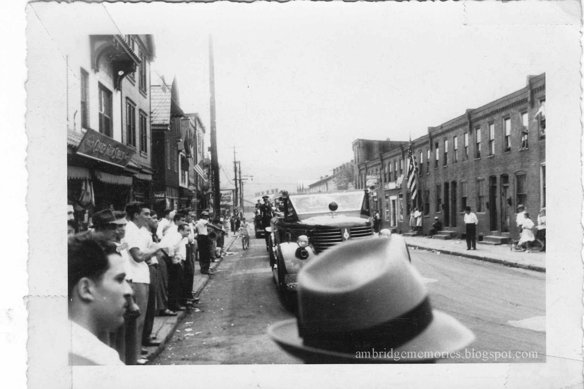
Five young men, 5th and Merchant Sts., 1947


3rd from left, Pete Lusty
2nd from left, John Smetanka
other young men unknown
1947
courtesy Dave Lusty

Dave Lusty, AHS '72, sent me this photo of his father, Pete Lusty, and four of his buddies, posing on the west side of Merchant St. near 5th St. in 1947. Pete Lusty would have been 20 years old at the time.

John Smetanka is the only of the four other young men that Dave could identify. If you know who any of the other three are, please leave a comment or contact me.

Note the streetcar tracks on Merchant St. Street cars through Ambridge were replaced by buses in 1934, but the tracks on Merchant St. weren't covered until 1958.

On the east side of Merchant, you can see the Penn Theatre's marquee. To the theater's right: The Penn Grill restaurant and Denmark's shoe store,

The building with the clock is the Economy Bank of Ambridge which was across 5th St. at 500 Merchant.

The Penn Theatre closed in the early 1950s, and the Melody Ballroom opened in the theater's former location in September 1953. The ballroom, Penn Grill, and Denmark's were all badly damaged in a big July 1954 fire. Another massive fire damaged the businesses that occupied the former theater in February 1963: the Bride and Deb Shop on the corner, Penn Grill, and Hankins Shoe Store. 

The former Penn Theatre building was razed after the 1963 fire, replaced by a parking lot. More recently, that corner was the location of the now-closed PNC Bank in 1984

The Economy Bank building was razed in 1984. WesBanco's drive though is now located where the bank once stood. 

Friday, December 17, 2021

The new block of 4th Street: Park Road to Ohio River Blvd., 1945 - '46

 
Intersection of Park Rd. and 4th St.
April 10, 1946
Laughlin Memorial Library archives

The photo above shows the practically brand-new intersection of Park Rd. and 4th St. The photo must have been taken from the American Bridge Office building which stood southwest of the new intersection.

John Domansky IDed the small building on the southwest corner of the intersection as belonging to the gas company. But so far, I don't have any confirming information.

Here are more views of the new brick-paved intersection:

Intersection of Park Rd. and 4th St.
north side of American Bridge Office shown on upper left
American Bridge Co. plant in background, right
April 10, 1946
Laughlin Memorial Library archives


Intersection of Park Rd. and 4th St.
looking west toward American Bridge Co. plant
American Bridge Office building on left
April 10, 1946
Laughlin Memorial Library archives


Intersection of Park Rd. and 4th St.
American Bridge Park on right
American Bridge Co. plant in background
April 4, 1946
Laughlin Memorial Library archives


Intersection of Park Rd. and 4th St.
looking toward 400 block of Park Rd.
April 10, 1946
Laughlin Memorial Library archives

That house on the corner of Park Rd. and 4th St. is still there, as is the darker house on Park Rd. above it, only now there's another house between them. 

During the spring and summer of 1945, that new block of 4th St. had been constructed to connect Park Rd. to the new extension of Ohio River Blvd. from the Allegheny County line to Ambridge's 8th St.

Ohio River Blvd. and 4th St.
construction
looking east from Ohio River Blvd.
American Bridge Office building on right
October 18, 1945
Laughlin Memorial Library archives


Ohio River Blvd. and 4th St. 
construction on 4th St.
American Bridge Co. plant in background
October 18, 1945
Laughlin Memorial Library archives


Construction of 4th St. between Park Rd. and Ohio River Blvd.
north side of American Bridge Office bldg.
October 18, 1945
Laughlin Memorial Library archives


Intersection of Park Rd. and 4th St.
looking west toward American Bridge plant
October 18, 1945
Laughlin Memorial Library archives

I believe that the sign to the right of the parked car says:
"Entrance at Merchant St. to American Bridge Co. and Penna. R. R. Station"

But extending 4th St. from Park Rd. to the boulevard had a legal complication: the land needed for the extension was owned by the American Bridge Co. The extension would go right through the American Bridge Park.

The legal issues involved in extending 4th St. through American Bridge's private property was nicely resolved in a "Deed of Dedication" which was memorialized as Ambridge Borough's Ordinance No. 562. Here's the beginning of the lengthy handwritten ordinance which included the signed deed:

An ordinance approving and accepting a Deed of Dedication from the American Bridge Company for the purpose of dedicating to public use that portion of Fourth Street, extended, in the said Borough of Ambridge, between Park Road and the new Pennsylvania State Highway.
In the deed, the American Bridge Co. agreed to give Ambridge Borough the legal right to the portion of 4th St. between Park Rd. and the new extension of Ohio River Blvd. For that right, Ambridge paid American Bridge Co. $1.00.
_____

Thanks to the Borough of Ambridge's Marilyn Sheleheda for scanning Ordinance No. 562 for me. The ordinance was not only not available online, but bound in a large book with other old handwritten ordinances. Scanning that couldn't have been easy.

Tuesday, December 14, 2021

Marketing the new town of Ambridge: Part 1: Porter Locomotive is coming! Porter Locomotive is coming! But did it?


Real Estate Trust Co. ad for Economy-Ambridge
"The H. K. Porter Company"
"Locomotive Shops to Employ 2,000 to 3,000 Men"
Pittsburg Press,
April 18, 1906

In 1903, the American Bridge Company started building the world's largest structural steel fabricating plant along the east side of the Ohio River. The building site was on land that had once belonged to the Harmony Society, which by then, had faded away, becoming history.

In the former Harmonist village of Economy, north of the new plant, a small number of non-Harmonist businesses and employees of the Society remained. But beyond the village, there was mostly undeveloped land: fields, orchards, vineyards, and pastures, occasionally punctuated by coke ovens and oil and gas wells.

Now think of what the American Bridge Co. had to do to start a thriving industrial town from basically scratch.

Sure, the company might have no problem attracting the massive labor force needed to build, then work in, their new plant. But think of everything those workers would need. Homes, food, supplies, transportation, banks, postal service, schools, churches. And what about infrastructure? Who would build streets, sidewalks, sewers, a water system? How do you attract professionals needed to care for the sick or bury the dead?

American Bridge did pretty much what's still done today. It hired a real estate company. And that company advertised.

The Real Estate Trust Co. of Pittsburgh, which had a branch office at the corner of Park Rd. and 5th St. in Ambridge, was given the task of selling the new town of Ambridge to potential businesses, investors, and residents. Early on, the company published a multi-page sales brochure, "Ambridge, Reasons for Her Coming Greatness," with descriptions and photos of the very early stages of the building of the American Bridge plant and Ambridge's infrastructure.

In May 1904, the real estate company placed two full-page ads in the Pittsburg* Press, touting the marvels of the new "manufacturing city" of Economy. The "Ambridge" name hadn't caught on yet.

The first ad, full of hyperbole and fantastic predictions, offered a free train excursion to see "the greatest industrial and city building progress in modern times." I highly recommend reading the ad; it's not only entertaining, but offers a jaw-dropping view of the early plans for Ambridge's development. (The ad's easiest to read if you visit the digital Pittsburg Press from May 3, 1904.)

Ad for "The Marvel City"
Pittsburg Press
May 23, 1904

The following day, the Press featured another full-page ad.

Ad for "The Marvel City"
Pittsburg Press
May 24, 1904

This second ad still contained some of the same amazing predictions about the future Ambridge as the previous day's ad did. But I think the seconds ad's most astonishing selling point was that it featured former Harmony Society trustee, "world's famous bandmaster," John Duss, saying his "greatest achievement" was selling "miles of level plateau to capitalists." (Click here to read the ad in the digital Pittsburg Press.)

In the spring of 1906, the same real estate company started placing a series of smaller ads in the Pittsburg PressPittsburgh Post, and Pittsburgh Gazette, this time focusing not on what Ambridge was going to become, but rather on what Ambridge already was.

The exception to these ads featuring Ambridge's already-existing amenities, buildings, and infrastructure were the earliest five that I found. Those five ads announced that the famous Porter Locomotive Co., which made small industrial locomotives used in places like mills, lumberyards, and mines, had plans for a huge new plant in Ambridge.

These Porter Locomotive ads were the only ones I've found in the series that were about an industry that was yet to come to Ambridge. And the only ads to feature the same reason Ambridge was wonderful more than once. Later, Porter Locomotive's coming to Ambridge was mentioned in several subsequent ads which I plan to feature in separate posts.


Real Estate Trust Co. ad for Economy-Ambridge
"Porter Locomotives Will Haul Money into Economy-Ambridge"
Pittsburgh Post,
April 20, 1906

Real Estate Trust Co. ad for Economy-Ambridge
"Porter Locomotive Shops"
"Double The Capacity of The Company's Present Shops"
Pittsburg Press,
April 22, 1906


Real Estate Trust Co. ad for Economy-Ambridge
"A Wonderful Engine"
"Economy = Ambridge"
Pittsburgh Post
April 24, 1906


Real Estate Trust Co. ad for Economy-Ambridge
"Realty Values in Economy-Ambridge Forge Ahead"
"one of the largest locomotive works in the world will commence operations"
Pittsburgh Post
April 26, 1906


Did Porter Locomotive ever come to Ambridge?

Over many months I've looked for information about the Porter Locomotive plant in Ambridge, so highly anticipated in 1906 and '07.

To be sure, Porter Locomotive's plans to move its existing Pittsburgh plant to a new plant in Ambridge wasn't just some advertising hoopla dreamed up by the Real Estate Trust Company to sell property. Not only was there information about the planned move in several newspapers, but also, thanks to Sarah Buffington, Old Economy Village's curator, I now have a copy of a 1906 deed showing that the H. K. Porter Co. bought property, not exactly in Ambridge, but rather a bit north, in Harmony Township's Legionville.   

And yes, in 1959, the H. K. Porter Corp. purchased Ambridge's National Electric plant. But by then Porter was no longer making locomotives, and National Electric, which produced electrical products, wasn't located on the property that Porter Locomotive bought in Legionville in 1906.

It looks to me as if Porter Locomotive's Pittsburgh plant remained opened. And that Porter Locomotive may have opened additional plants in locations other than Ambridge. 

I found no information about Porter Locomotive ever building a plant, hiring workers, or producing locomotives in Legionville or Ambridge. Did any of that ever happen?

I've seen Porter Locomotive listed among Ambridge's industries in several places, but none provide more information than the name, and perhaps, mention that it was north of Ambridge. Although I checked with a couple of the writers who had said Porter Locomotive was in Ambridge, they couldn't offer me more information.

So, did Porter Locomotives ever build a plant and manufacture locomotives in or near Ambridge? I don't have the definitive answer to that yet. But right now, I'm inclined to say "no."

I do know that in 1917, Porter sold at least some of the Legionville property to the Firth Sterling Steel Co., and that Firth Sterling later sold the property to several buyers, but that's about it. One of the buyers was Spang Chalfant Co. which according to a March 21, 1939, Daily Citizen article, bought 55 acres on the flat area between the railroad and the Ohio River, previously an "old dairy farm."

There may be people who can tell me about Legionville's history during 1906 - 1917, and I know there are people who know a lot about the history of the Porter Locomotive Co. If anyone can help with additional information about what happened with the plan to move Pittsburgh's Porter Locomotive plant to Legionville, I'd be grateful.
_____

* For a time, the Pittsburgh Press spelled its name "Pittsburg Press," the no "h" spelling dictated by the United States Board on Geographic Names. Other Pittsburgh papers kept the "h". Eventually, the Pittsburgh Press added the "h" back.

Saturday, July 31, 2021

Ambridge parade on First St. 1955

Ambridge Golden Jubilee's Miss Greater Ambridge, Helen Witek
National Electric float
intersection First and Merchant Sts.
background: Karas Place, Balkan Restaurant, 291 First St.

Patrick Escoto* let me scan some photos that belonged to his late father, Phillip "Pippy" Escote.* Among the photos were some from a parade along what I recognized as Ambridge's First St. before the the neighborhood was razed, beginning with the Marshall Alley buildings in the mid-1950s, then more extensively in the early 1970s, when the entire area was cleared for redevelopment. 

The photos didn't give the date of the parade, or identify the parade participants or the spectators.

However, I am pretty certain that the photos were of Ambridge's Golden Jubilee parade on July 2, 1955, even though I haven't been able to find photos showing the same participants in the news photos of the parade that Ambridge's Daily Citizen called "a massive spectacle."

My best clue so far that these photos are of the Golden Jubilee parade is the Miss Greater Ambridge parade float above, on which Helen Witek, who was chosen for that honor as part of Ambridge's Golden Jubilee celebration, was riding with her court.

None of the different majorette or drum major uniforms in any of the photos match the ones worn at Ambridge High School in the mid-1950s according to photos in the 1954, '55, or '56 Bridger yearbooks. But there were many many marching units in the parade. Recognize anyone?

The very long parade was staged along the 100 and 200 blocks of First St., and then north on Park Rd. But the parade officially started at the intersection of First and Merchant Sts., which once began between the 200 and 300 blocks of First St. So the lucky residents of First St. got to see the parade before those watching elsewhere in Ambridge did.

If you can provide identifying information (people, float sponsors, businesses), or memories of the parade traveling up First St., please leave a comment.

Here are the rest of the Escoto parade photos in no particular order:

All photos in this post are courtesy of Patrick Escoto.
 
Firetruck
parade traveling along the 200 block of First St.
a row of Marshall Alley buildings on right
on left: Grosdeck's Clover Farm Store, 290-292 First St.


8th St. Toppers float
 making the turn from First St. onto Merchant St.
In background:
Canteen Luncheonette, 300 First St.,
Blossom Grill 296 First St.


Motorcyclist and police cars traveling east on 200 block of First St.
in background at end of street: American Bridge Co.


1916 model car
unidentified driver and passengers
right side: Karas Place, Balkan Restaurant, 291 First St.


Unidentified kilted bagpipers
right side: Karas Place, Balkan Restaurant, 291 First St.


Unidentified Navy flagbearers
200 block First St.
far background, end of street: American Bridge Co.


Conway Airport, Ben Mauro Co. Aviation Division entry
unidentified passenger
200 block First St.
on right: Karas Place, Balkan Restaurant, 291 First St.


Unidentified majorettes
buildings in background: 100, 102, 104, 106 Merchant St.


Taylor's Dairy truck with unidentified clown
200 block First St.
on right: Karas Place, Balkan Restaurant, 291 First St.


Ambridge B.P.O. Elks float
in background: Karas Place, Balkan Restaurant, 291 First St., 
to the right: end units of two rows of Marshall Alley buildings


Unidentified majorettes and drum major
unidentified location


CIO Local 1211 entry
making turn from 200 block First St. onto Merchant St.


Unidentified drum major and majorettes, unidentified spectators
unidentified location


Unidentified majorettes
in background: Karas Place, Balkan Restaurant, 291 First St.


Unidentified color guard and band
200 block First St.


Hot Tamales
representing American Bridge Co. and CIO Local 1270
200 block of First St.


Unidentified rider
Hot Tamales, American Bridge, CIO Local 1270 float
CIO Local 1270 car
on right:
Jimmy's Place, 294 First St.
Blossom Grill, 296 First St. 


Fraternal Order of Eagles 1365
200 block First St.
row of Marshall Alley homes on right


Pittsburgh Mercantile Co. float
on right:
Karas Place, Balkan Restaurant, 291 First St.


Unidentified rider
background: Jimmy's Place, 294 First St.


United Polish Societies entry making turn onto Merchant
On right: Blossom Grill, 296 First St.
buildings on left: on corner: 101 Merchant St.; behind, 303 and 305 First St. 


Unidentified float and revelers 
First and Merchant Sts.
buildings in background: on corner, 100 Merchant St.; behind, 303 and 305 First St.


Unidentified revelers
First and Merchant Sts.
buildings in background: on corner 100 Merchant St.; behind, 303 and 305 First St.
_____

* Not a typo. Patrick Escoto and his father spelled their last names differently.

Thursday, March 18, 2021

Coffee Pot Inn, Duss Ave., 1929

Coffee Pot Inn
Duss Ave., Near New Byers Plant
ad
Daily Citizen 
August 10, 1929
 

Ever since I first saw this ad for the Coffee Pot Inn ("Hot Bar-B-Q Open All Year") when Maria Notarianni shared a scan of it with me several years ago, I've wondered exactly where on "Duss Ave., Near New Byers Plant" it was.

And then recently, while looking for something else entirely, I found the answer in The Pittsburgh Catholic, Sept. 22, 1932, issue, in an ad for a different Ambridge inn: the Golden Moon Inn, "Formerly Coffee Pot Inn."

The Golden Moon Inn ad advertised "Delicious BAR B Q--10¢. No Cover Charge; Dine and Dance; Private Parties and Banquets a Specialty."

Golden Moon Inn
"Formerly Coffee Pot Inn"
3000 Duss Ave.
ad
Pittsburgh Catholic
September 22, 1932

The address in the Golden Moon ad, 3000 Duss Ave., no longer exists. But if it still did, it would be as far north on Duss as possible without crossing the Legionville Bridge into Baden.

But perhaps the Coffee Pot Inn and the Golden Moon Inn weren't actually located that far north on Duss. I have a later address for the Golden Moon Inn, 2916 Duss Ave., which would have put it more or less across the street from where the Byers plant's office was. So either the Golden Moon had moved further south on Duss, or the buildings on that part of Duss were renumbered at some point so 3000 Duss became 2916 Duss. Does anyone know?

I've also wondered what that cute little building on the Coffee Pot Inn's right side was. Phone booth?  

Thursday, November 12, 2020

Laundry day, Ambridge's Marshall Alley homes, July 1938


Laundry hung between some Marshall Alley homes
"Housing conditions in Ambridge, Pennsylvania, home of the American Bridge Company"
Photographer: Arthur Rothstein
Library of Congress Prints and Photographs Division
July 1938


It must be laundry day in some Marshall Alley homes. 

This is another of a series of photos photojournalist Arthur Rothstein took in July 1938 as part of a project for the Farm Security Administration, documenting life during the Great Depression. 

Most of the photos Rothstein took in Ambridge focused on the First St. area. The iconic photo of the Dead-End Pool built by First St. children, and the frequently shared photo of a girl in a wash tub, were taken by Rothstein.

The Marshall Alley projects consisted of three rows of homes, only two of which were on Marshall Alley. The third row faced First St. The rows ran between Merchant St. and Maplewood Ave. They were built circa 1904 and housed some of Ambridge's poorest families.

Location of Marshall Alley homes
snip from 1923 Sanborn Insurance map

Because the homes which were actually on Marshall Alley faced each other, as shown in the blog post "The children of Marshall Alley," and this photo shows the backs of two rows, it must have been taken behind the First St. row of homes. So in a Marshall Alley alley. 

Those are not outhouses attached to the back of the houses. I've been told that
 the additions were meant to help keep out the cold and dirt. I'm not sure how successful they were. Although the homes did not have a bathroom, each had a toilet in the basement. Someone who lived in a Marshall Alley home as a child remembered the basement as a dark and scary place, with rats scurrying past when someone came down the stairs. 

Laundry would probably have been done in big metal tubs like the one in the "girl in a wash tub" photo, with water heated on the stove, and perhaps scrubbed on washboards. 

The Marshall Alley homes were razed in the 1950s.

Sunday, September 27, 2020

Big Sewickley Creek Bridge 1917: "Longer to complete than did the building of the Panama Canal"


Big Sewickley Creek Bridge
From Allegheny Co. looking north into Ambridge, Beaver County
1917
credit: Allegheny Co. Dept. of Public Works


About the photo above:

Streetcar tracks crossed the bridge in 1917. The dark building just above the photo's center and the first building on the right were on the part of Beaver Rd./Beaver St. that leads into Ambridge from the bridge. To the dark building's left is a home that I think was on Bank St. and the backs of some buildings in the 300 block of First St. The dark building and all buildings to its left have been razed. The tall building farther up the left side of the street must be the S. P. Kristufek Department Store. If you enlarge the photo enough, you can see a horse standing next to the Kristufek store. And, above the first utility pole on the right, a carriage.

The nearest building on the right is still standing; Hark's Place bar is now there, 70 Beaver St./Rd. Beyond that, the building with all the porches was one of the infamous "Crackerbox" tenements that stood on the hill above Merchant St./Beaver Rd., razed in 1960.

Far in the background are homes in the 100 block of Merchant St. And behind them, the domes of Holy Ghost Orthodox Church, 210 Maplewood Ave.

_____

Long before Ohio River Boulevard connected Ambridge with Allegheny Co., the small Big Sewickley Creek Bridge provided the connection.

The Economy Centennial was being celebrated when Ambridge's June 6, 1924, Citizen* newspaper noted on its front page: 
an important milestone in the history of Ambridge...the beginning of the end of the work on the Big Sewickley Creek bridge between Ambridge and Fair Oaks, which has been a bone of contention between two counties, a street car company, residents of three boroughs and tourists of 48 States for a number of years.
Because that very morning, a contractor had started pouring concrete in the bridge's road bed and expected the work to be completed "in about two weeks."

Even though the bridge is only about 200 feet long, that same Citizen article claimed it took "longer to complete than did the building of the Panama Canal and has cost enough to build a bridge across the Ohio River."

The history of the bridge's construction is murky. The Citizen article said Allegheny County records showed a bridge at the site    "[96] years ago" according to a construction inspector, who said he had found a 1828 "road view plan" showing a bridge at the same location.

However, the inspector's history was questioned by John Frederick (Fred) Knoedler, who was a non-Harmonist caretaker of Old Economy and its property both before and after the Harmony Society dissolved. Knoedler said that according to Harmonist records, "the Economites drove through the creek to get to Leetsdale" during their early years in Economy. But, he says, "much later," there was a bridge across the creek when the Harmonists had pastures on both sides of Big Sewickley Creek. Knoedler remembered "wire gates hung from the bridge to keep the [Harmony Society's] cattle from going up the creek." 

The Citizen also said that "during the youth of John Duss," who was born in 1860, the bridge was condemned, and Duss designed an arch under the bridge to strengthen it. "The original arch still stands, but is is now encased in concrete."

A 1906 G. M. Hopkins & Co. map shows a narrow bridge in that spot. Eventually, the bridge was raised and the walls heighted to accommodate street cars.

Then, during the WWI years, a decision was made by some entity to further widen and rebuild the bridge. Beaver County's commissioners claimed they had no money for such a project. So Allegheny Co. undertook the work on its own. I believe the photo above shows that reconstruction project. 

But the work did not go well. In fact it went so wrong that The Citizen said:
The [whale] may have swallowed Jonah, according to tradition, but no one who ever had any thing to do with the Big Sewickley Creek Bridge from that time on would believe that Jonah was anywhere but right handy to that bridge. His hoodoo seemed to be always present.
What was supposed to be a one year project took two. Twice high water moved the derrick. Once all the bridge's "large stones were washed down the creek, requiring lines to be tied to them to 'snake' them out of the creek." 

Even after the construction project finished, problems continued when the streetcar company said it wouldn't pay to move its tracks. So in 1923, the two counties agreed to do the job themselves. But then, after the contractor had moved one of the tracks, he claimed that he didn't have enough money to finish the job. And the work dragged on and on into the spring on 1924--bad weather didn't help. But finally--finally--the bridge construction appeared to be nearing completion.

But wait, there's more!

If you enlarge the photo at the top, you can see what appears to be the back of a carriage, and near that carriage, part of a sign peeking out on the right side of a pole. And if you're like me, you thought, "I wish I could read what that sign says. 

Well, wish granted. Because there's another photo! And while the photo was focused on the bridge's stone arch, it shows more than that.

Big Sewickley Creek Bridge
from the Allegheny County side of Big Sewickley Creek
1917
credit: Allegheny Co. Dept. of Public Works

First, an enlargement of the sign: 

Ambridge speed limit sign
Merchant St. near Valley Rd.
1917

About the photo above:

The sign says "Ambridge Borough, Speed Limit, 15 miles per hour." It appears to have stood about where the "Welcome to the Borough of Ambridge" sign is now, just north of the intersection of Valley Rd. and Merchant St.

An enlarged photo also shows a tailor's signs painted on the windows of the building with the awning, now Hark's Place.  I think the left window says "Merchant Tailor." The one on the right window says "John [last name I couldn't read], Tailor."

The sign on the side of the one story wooden building says "Favorite Cigarettes." While there are more signs on the side and on the front, I can't make them out. 

Could the house on the right side of the photo, above those two buildings, have been on Valley Rd.? And the houses on the very top of the hill on Glenwood Dr.?

And towards the right side of the photo, a man wearing a hat is standing, looking toward the photographer. And us.

_____

Thanks to Debby Rabold, Bell Acres Borough's historian, for sending me the two photos above. Debby has also written about the Ambridge-Leetsdale Big Sewickley Creek Bridge and provides a somewhat different history of its construction than the one written in The Citizen. She also has included some early photos of that bridge. Here's a link to Debby's article: "Big Sewickley Creek...Early Bridges," which also includes information about other bridges that cross Big Sewickley Creek. 
_____

* The Citizen's June 6, 1924, article was republished in the March 21, 1939, Daily Citizen. The latter did correct several typos in the original article, including that a bridge was at the site "6 years ago." That befuddled me at first, because I knew that the bridge had been built before 1918. In 1939, the bridge was referred to as the "Ambridge-Fair Oaks Bridge."

Sunday, April 5, 2020

500 block of Maplewood Ave. circa 1907 - 1913

These two vintage postcards show the 500 block of Maplewood Ave. from 5th St. looking north.

The upper card is the older of the two scenes. If you compare the two postcards, you'll see this first scene doesn't have the trees planted along the street that are shown in the lower card.

Note the horse and wagon way down the block, left side of the upper card.

The upper postcard with the older scene was never mailed, so there's no postmark to try to date the scene. But since the later postcard was mailed, and postmarked 1913, the scene on the older view must have been earlier.

More clues as to the date of the older postcard: Both postcards have divided backs on the address side, a style that the post office only allowed to be used beginning in 1907, so I know that the older postcard dates from after 1907. And before 1913. *

500 block of Maplewood Ave. looking north from 5th St.
postcard
circa 1907 - 1913

Compare the scenes in both postcards with this "now" photo taken by P. J. Shotter. Most of the houses shown in the two postcards are still there. As far as I can determine, the modern flat-roofed building on the right side of the photo, 510 Maplewood, was built on the last empty lot on the block in the 1950s. A podiatrist is there now. Earlier, it was was a dental office for many years.

500 block of Maplewood Ave. looking north from 5th St.
March 8, 2020
credit: P. J. Shotter

There's one other difference I see between the two cards: there's a house not in the older scene that's shown in the later one: 517 Maplewood, the third house on the left side of the later scene with the peaked roof and brown shingles at the top.

500 block of Maplewood Ave. looking north from 5th St.
postcard
postmarked 1913

Beaver County property records say 517 was built in 1916 which isn't possible. The house has to be older since it appears on a 1911 Sanborn insurance map** and the postcard mailed in 1913.

The yellow brick house with the pointed roof on the left side of the street in the "now" photo is also 517, so brick veneer may have been added after 1913. Better guess (maybe): although the postcard was mailed in 1913, the scene on the postcard predates 1911, since the 1911 Sanborn insurance map indicates the house was veneered. Either that, or the coloring of the houses on the postcard isn't accurate.

Here's the latest Google Street View of 517 and the neighboring houses on both sides:

515, 517, and 521 Maplewood Ave.
Google Street View
July 2019

Most of the street trees shown in the later postcard scene are now gone, although a few remain nearer to 6th St.  I wonder if they were some of the 200 - 300 trees planned for Ambridge for which the "shade tree commission" was accepting bids in 1908. (Daily Citizen, August 25, 1954)
_____

Personal memory: I spent many happy visits to 517 Maplewood when my Uncle and Aunt, Pete and Helen Gause, lived there with my three cousins.

* And yes, I realize that just because the postcard was printed in 1907 that also means the scene on the card is from 1907. But the October 1905 Sanborn insurance map shows more empty lots in the 500 block on Maplewood than the scene appears to show. So 1907 seems to be a good approximate date of the earlier scene.

** On the 1911 Sanborn map, the address of the house that is now 517 Maplewood house was 508. Building addresses in Ambridge were changed in 1917, making Ambridge history involving old buildings so much more fun.

Here's the address side of the two postcards:

Address side of 1907 postcard


Address side of 1913 postcard