Showing posts with label churches. Show all posts

Saturday, December 17, 2022

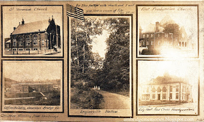
Vintage Ambridge Christmas postcard, circa 1918

"Christmas Greeting From Ambridge"
unposted vintage postcard
circa 1918
personal collection

In the left bottom corner of this card it says, "Christmas Greeting from Ambridge."

Shown on the card with photos' captions:

Left, top: St. Veronica's Church; bottom: Office Building American Bridge Co.

Right, top: First Presbyterian Church; bottom: City Hall, Red Cross Headquarters

Center: Legionville Hollow

Because the other four photos show notable Ambridge buildings, the choice of a scene showing three women strolling in a wooded Legionville Hollow lane as the larger center photo seems to me like an unusual choice. Maybe the scene held some special importance. Or maybe it was simply pretty. Or maybe it just fit better in the vertical space.

The American flag and bible verse at the top seem surprising for a Christmas card: "Be thou faithful unto death, and I will give thee a crown of life." (Rev. 2nd - 10). So merry. But I don't claim any expertise in vintage Christmas postcards, so maybe those are typical for the time.

This divided back postcard, now faded on the right side, was unmailed and had nothing written on the back. I based the "circa 1918" date, in part, on the photo of the First Presbyterian Church showing the church's "auditorium" that was dedicated in December 1917, after it was added to the right side of the earlier "chapel."

The flag, bible verse, and the "City Hall" (Ambridge's first Municipal Building) being described as the Red Cross Headquarters added to my thinking that this postcard might date from one of the U.S.'s WWI years (1917 - 1918), but I can't say with certainty. As do the dresses worn by the women in the Legionville Hollow photo.

Tuesday, December 14, 2021

Marketing the new town of Ambridge: Part 1: Porter Locomotive is coming! Porter Locomotive is coming! But did it?


Real Estate Trust Co. ad for Economy-Ambridge
"The H. K. Porter Company"
"Locomotive Shops to Employ 2,000 to 3,000 Men"
Pittsburg Press,
April 18, 1906

In 1903, the American Bridge Company started building the world's largest structural steel fabricating plant along the east side of the Ohio River. The building site was on land that had once belonged to the Harmony Society, which by then, had faded away, becoming history.

In the former Harmonist village of Economy, north of the new plant, a small number of non-Harmonist businesses and employees of the Society remained. But beyond the village, there was mostly undeveloped land: fields, orchards, vineyards, and pastures, occasionally punctuated by coke ovens and oil and gas wells.

Now think of what the American Bridge Co. had to do to start a thriving industrial town from basically scratch.

Sure, the company might have no problem attracting the massive labor force needed to build, then work in, their new plant. But think of everything those workers would need. Homes, food, supplies, transportation, banks, postal service, schools, churches. And what about infrastructure? Who would build streets, sidewalks, sewers, a water system? How do you attract professionals needed to care for the sick or bury the dead?

American Bridge did pretty much what's still done today. It hired a real estate company. And that company advertised.

The Real Estate Trust Co. of Pittsburgh, which had a branch office at the corner of Park Rd. and 5th St. in Ambridge, was given the task of selling the new town of Ambridge to potential businesses, investors, and residents. Early on, the company published a multi-page sales brochure, "Ambridge, Reasons for Her Coming Greatness," with descriptions and photos of the very early stages of the building of the American Bridge plant and Ambridge's infrastructure.

In May 1904, the real estate company placed two full-page ads in the Pittsburg* Press, touting the marvels of the new "manufacturing city" of Economy. The "Ambridge" name hadn't caught on yet.

The first ad, full of hyperbole and fantastic predictions, offered a free train excursion to see "the greatest industrial and city building progress in modern times." I highly recommend reading the ad; it's not only entertaining, but offers a jaw-dropping view of the early plans for Ambridge's development. (The ad's easiest to read if you visit the digital Pittsburg Press from May 3, 1904.)

Ad for "The Marvel City"
Pittsburg Press
May 23, 1904

The following day, the Press featured another full-page ad.

Ad for "The Marvel City"
Pittsburg Press
May 24, 1904

This second ad still contained some of the same amazing predictions about the future Ambridge as the previous day's ad did. But I think the seconds ad's most astonishing selling point was that it featured former Harmony Society trustee, "world's famous bandmaster," John Duss, saying his "greatest achievement" was selling "miles of level plateau to capitalists." (Click here to read the ad in the digital Pittsburg Press.)

In the spring of 1906, the same real estate company started placing a series of smaller ads in the Pittsburg PressPittsburgh Post, and Pittsburgh Gazette, this time focusing not on what Ambridge was going to become, but rather on what Ambridge already was.

The exception to these ads featuring Ambridge's already-existing amenities, buildings, and infrastructure were the earliest five that I found. Those five ads announced that the famous Porter Locomotive Co., which made small industrial locomotives used in places like mills, lumberyards, and mines, had plans for a huge new plant in Ambridge.

These Porter Locomotive ads were the only ones I've found in the series that were about an industry that was yet to come to Ambridge. And the only ads to feature the same reason Ambridge was wonderful more than once. Later, Porter Locomotive's coming to Ambridge was mentioned in several subsequent ads which I plan to feature in separate posts.


Real Estate Trust Co. ad for Economy-Ambridge
"Porter Locomotives Will Haul Money into Economy-Ambridge"
Pittsburgh Post,
April 20, 1906

Real Estate Trust Co. ad for Economy-Ambridge
"Porter Locomotive Shops"
"Double The Capacity of The Company's Present Shops"
Pittsburg Press,
April 22, 1906


Real Estate Trust Co. ad for Economy-Ambridge
"A Wonderful Engine"
"Economy = Ambridge"
Pittsburgh Post
April 24, 1906


Real Estate Trust Co. ad for Economy-Ambridge
"Realty Values in Economy-Ambridge Forge Ahead"
"one of the largest locomotive works in the world will commence operations"
Pittsburgh Post
April 26, 1906


Did Porter Locomotive ever come to Ambridge?

Over many months I've looked for information about the Porter Locomotive plant in Ambridge, so highly anticipated in 1906 and '07.

To be sure, Porter Locomotive's plans to move its existing Pittsburgh plant to a new plant in Ambridge wasn't just some advertising hoopla dreamed up by the Real Estate Trust Company to sell property. Not only was there information about the planned move in several newspapers, but also, thanks to Sarah Buffington, Old Economy Village's curator, I now have a copy of a 1906 deed showing that the H. K. Porter Co. bought property, not exactly in Ambridge, but rather a bit north, in Harmony Township's Legionville.   

And yes, in 1959, the H. K. Porter Corp. purchased Ambridge's National Electric plant. But by then Porter was no longer making locomotives, and National Electric, which produced electrical products, wasn't located on the property that Porter Locomotive bought in Legionville in 1906.

It looks to me as if Porter Locomotive's Pittsburgh plant remained opened. And that Porter Locomotive may have opened additional plants in locations other than Ambridge. 

I found no information about Porter Locomotive ever building a plant, hiring workers, or producing locomotives in Legionville or Ambridge. Did any of that ever happen?

I've seen Porter Locomotive listed among Ambridge's industries in several places, but none provide more information than the name, and perhaps, mention that it was north of Ambridge. Although I checked with a couple of the writers who had said Porter Locomotive was in Ambridge, they couldn't offer me more information.

So, did Porter Locomotives ever build a plant and manufacture locomotives in or near Ambridge? I don't have the definitive answer to that yet. But right now, I'm inclined to say "no."

I do know that in 1917, Porter sold at least some of the Legionville property to the Firth Sterling Steel Co., and that Firth Sterling later sold the property to several buyers, but that's about it. One of the buyers was Spang Chalfant Co. which according to a March 21, 1939, Daily Citizen article, bought 55 acres on the flat area between the railroad and the Ohio River, previously an "old dairy farm."

There may be people who can tell me about Legionville's history during 1906 - 1917, and I know there are people who know a lot about the history of the Porter Locomotive Co. If anyone can help with additional information about what happened with the plan to move Pittsburgh's Porter Locomotive plant to Legionville, I'd be grateful.
_____

* For a time, the Pittsburgh Press spelled its name "Pittsburg Press," the no "h" spelling dictated by the United States Board on Geographic Names. Other Pittsburgh papers kept the "h". Eventually, the Pittsburgh Press added the "h" back.

Sunday, September 27, 2020

Big Sewickley Creek Bridge 1917: "Longer to complete than did the building of the Panama Canal"


Big Sewickley Creek Bridge
From Allegheny Co. looking north into Ambridge, Beaver County
1917
credit: Allegheny Co. Dept. of Public Works


About the photo above:

Streetcar tracks crossed the bridge in 1917. The dark building just above the photo's center and the first building on the right were on the part of Beaver Rd./Beaver St. that leads into Ambridge from the bridge. To the dark building's left is a home that I think was on Bank St. and the backs of some buildings in the 300 block of First St. The dark building and all buildings to its left have been razed. The tall building farther up the left side of the street must be the S. P. Kristufek Department Store. If you enlarge the photo enough, you can see a horse standing next to the Kristufek store. And, above the first utility pole on the right, a carriage.

The nearest building on the right is still standing; Hark's Place bar is now there, 70 Beaver St./Rd. Beyond that, the building with all the porches was one of the infamous "Crackerbox" tenements that stood on the hill above Merchant St./Beaver Rd., razed in 1960.

Far in the background are homes in the 100 block of Merchant St. And behind them, the domes of Holy Ghost Orthodox Church, 210 Maplewood Ave.

_____

Long before Ohio River Boulevard connected Ambridge with Allegheny Co., the small Big Sewickley Creek Bridge provided the connection.

The Economy Centennial was being celebrated when Ambridge's June 6, 1924, Citizen* newspaper noted on its front page: 
an important milestone in the history of Ambridge...the beginning of the end of the work on the Big Sewickley Creek bridge between Ambridge and Fair Oaks, which has been a bone of contention between two counties, a street car company, residents of three boroughs and tourists of 48 States for a number of years.
Because that very morning, a contractor had started pouring concrete in the bridge's road bed and expected the work to be completed "in about two weeks."

Even though the bridge is only about 200 feet long, that same Citizen article claimed it took "longer to complete than did the building of the Panama Canal and has cost enough to build a bridge across the Ohio River."

The history of the bridge's construction is murky. The Citizen article said Allegheny County records showed a bridge at the site    "[96] years ago" according to a construction inspector, who said he had found a 1828 "road view plan" showing a bridge at the same location.

However, the inspector's history was questioned by John Frederick (Fred) Knoedler, who was a non-Harmonist caretaker of Old Economy and its property both before and after the Harmony Society dissolved. Knoedler said that according to Harmonist records, "the Economites drove through the creek to get to Leetsdale" during their early years in Economy. But, he says, "much later," there was a bridge across the creek when the Harmonists had pastures on both sides of Big Sewickley Creek. Knoedler remembered "wire gates hung from the bridge to keep the [Harmony Society's] cattle from going up the creek." 

The Citizen also said that "during the youth of John Duss," who was born in 1860, the bridge was condemned, and Duss designed an arch under the bridge to strengthen it. "The original arch still stands, but is is now encased in concrete."

A 1906 G. M. Hopkins & Co. map shows a narrow bridge in that spot. Eventually, the bridge was raised and the walls heighted to accommodate street cars.

Then, during the WWI years, a decision was made by some entity to further widen and rebuild the bridge. Beaver County's commissioners claimed they had no money for such a project. So Allegheny Co. undertook the work on its own. I believe the photo above shows that reconstruction project. 

But the work did not go well. In fact it went so wrong that The Citizen said:
The [whale] may have swallowed Jonah, according to tradition, but no one who ever had any thing to do with the Big Sewickley Creek Bridge from that time on would believe that Jonah was anywhere but right handy to that bridge. His hoodoo seemed to be always present.
What was supposed to be a one year project took two. Twice high water moved the derrick. Once all the bridge's "large stones were washed down the creek, requiring lines to be tied to them to 'snake' them out of the creek." 

Even after the construction project finished, problems continued when the streetcar company said it wouldn't pay to move its tracks. So in 1923, the two counties agreed to do the job themselves. But then, after the contractor had moved one of the tracks, he claimed that he didn't have enough money to finish the job. And the work dragged on and on into the spring on 1924--bad weather didn't help. But finally--finally--the bridge construction appeared to be nearing completion.

But wait, there's more!

If you enlarge the photo at the top, you can see what appears to be the back of a carriage, and near that carriage, part of a sign peeking out on the right side of a pole. And if you're like me, you thought, "I wish I could read what that sign says. 

Well, wish granted. Because there's another photo! And while the photo was focused on the bridge's stone arch, it shows more than that.

Big Sewickley Creek Bridge
from the Allegheny County side of Big Sewickley Creek
1917
credit: Allegheny Co. Dept. of Public Works

First, an enlargement of the sign: 

Ambridge speed limit sign
Merchant St. near Valley Rd.
1917

About the photo above:

The sign says "Ambridge Borough, Speed Limit, 15 miles per hour." It appears to have stood about where the "Welcome to the Borough of Ambridge" sign is now, just north of the intersection of Valley Rd. and Merchant St.

An enlarged photo also shows a tailor's signs painted on the windows of the building with the awning, now Hark's Place.  I think the left window says "Merchant Tailor." The one on the right window says "John [last name I couldn't read], Tailor."

The sign on the side of the one story wooden building says "Favorite Cigarettes." While there are more signs on the side and on the front, I can't make them out. 

Could the house on the right side of the photo, above those two buildings, have been on Valley Rd.? And the houses on the very top of the hill on Glenwood Dr.?

And towards the right side of the photo, a man wearing a hat is standing, looking toward the photographer. And us.

_____

Thanks to Debby Rabold, Bell Acres Borough's historian, for sending me the two photos above. Debby has also written about the Ambridge-Leetsdale Big Sewickley Creek Bridge and provides a somewhat different history of its construction than the one written in The Citizen. She also has included some early photos of that bridge. Here's a link to Debby's article: "Big Sewickley Creek...Early Bridges," which also includes information about other bridges that cross Big Sewickley Creek. 
_____

* The Citizen's June 6, 1924, article was republished in the March 21, 1939, Daily Citizen. The latter did correct several typos in the original article, including that a bridge was at the site "6 years ago." That befuddled me at first, because I knew that the bridge had been built before 1918. In 1939, the bridge was referred to as the "Ambridge-Fair Oaks Bridge."

Wednesday, April 8, 2020

Zion Lutheran Church's landmark parsonage razed

Zion Lutheran Church's parsonage being razed
8th St. between Park Rd. and Maplewood Ave.
Daily Citizen
November 2, 1948

Daily Citizen caption:
The former Zion Lutheran church parsonage on Park Rd. near Eighth St. is being razed. Constructed some 47 years ago, it is a landmark of the community. The residence was vacated when the congregation erected a modern home for their pastor, Rev. Frederick B. Haer and family, on the corner lot, Maplewood and 8th St.
If the parsonage was built in 1901, as the caption indicates, that means it was standing before there was an Ambridge, predating the building of the American Bridge plant. And it would have been older than the first Zion Lutheran Church, for which construction started in 1904. No wonder it was a landmark.

Although the caption describes the parsonage as being "on Park Rd. near Eighth St.," it actually sat very close to 8th St., about half way between Park Rd. and Maplewood Ave.

An article about the new parsonage in the September 16, 1948, Daily Citizen, said that the plan was to sell the old parsonage, but it was demolished less than two months later instead. Perhaps the congregation, thinking ahead, decided to retain the property so it might eventually build a new church building there?

Here's a photo of the replacement parsonage, still on the corner of Maplewood Ave. and 8th St., after construction was completed, and the pastor was getting ready to move in.

"Zion First Lutheran Church Parsonage Completed"
Daily Citizen
September 16, 1948

Sunday, May 6, 2018

Eleventh and Merchant Sts. circa 1935 - 36

Ambridge Post Office under construction
circa 1935 - 36
courtesy First Baptist Church of Ambridge

I had never seen this wonderful photo showing the construction of the Ambridge Post Office before the pastor of the First Baptist Church of Ambridge, Rev. Matt Klenk, showed it to me. Rev. Matt found it in an old storage box at the church.

In the foreground, the foundation for the Ambridge Post Office, 1020 Merchant St., is being built. Although the photo isn't dated, ground was broken for the post office on Nov. 25, 1935, and the building was dedicated Aug. 15, 1936.

But while an early photo of the post office's construction is nice, I think it's the inclusion of the buildings in the background that make this photo special.

The photo was shot looking northwest from the Post Office.

The building with snow on the roof is the First Baptist Church, 300 Eleventh St., not looking much different than it does today. The church was built in 1917.

Peeking out to the church's left is Laughlin Memorial Library, 99 Eleventh St., dedicated in 1929.

The long building in the background on the right side is now the location of the Tick Tock. According to Beaver County real estate assessment records, the building at 1101 Merchant St. was built in 1920; however, there are no buildings on the northwest corner of 11th and Merchant shown on a 1924 insurance map, so I'm puzzled. I'll keep looking for more information, including the name of the business that was in that building in 1936.

And look! There's already a gas station on the southwest corner of 11th and Merchant. I wish I could read the name on the station's sign. There's a BP and Ambridge Mini Mart on that corner now.

Monday, April 9, 2018

Ambridge view from a hill, 1905

I remember seeing the postcard below before I became so interested in Ambridge history and wondering back then if the photo was really of Ambridge. It's hard to identify old buildings from the sides, backs, and roofs, especially when the photo isn't sharp. Nothing looked familiar to me. And I couldn't see any of the familiar landmarks that would tell me "this can only be Ambridge," like the Old Economy church tower or the American Bridge office building. Is it possible the town might have been misidentified?

I know I wasn't the only person wondering about the identity of the town in the photo, because I've been asked "Is this really Ambridge?" several times. But I can now say with confidence, yes, it is Ambridge, because I have learned enough in the past several years to identify a few of the buildings. And a postcard message from 1905 helps too.

I've numbered the buildings I have IDed on the postcard. To see a larger view, click on the card:

Ambridge looking northwest from hill
circa 1905

While I've numbered the buildings from left to right, I'm going to start with #4 on the far right side, because, several years ago, that's the first building I thought I could identify.

#4. First St. Veronica Church, 8th St. and Glenwood Ave. Since razed.

St. Veronica Church
postcard
circa 1906

The next building I identified was #2, near the center:

#2. The long building with five single windows on the top floor, then groups of windows on the floor below, looks to me like the Ambridge Savings and Trust Co. building, once on the northeast corner of 5th and Merchant Sts., now also gone. The roof line is right.

Ambridge Savings and Trust buildings
5th and Merchant Sts.
circa 1920s
Louis Vukovcan collection
courtesy Jackie Vukovcan

#1. Based on the distinctive roof line with a cube on each end, I believe that #1 might be 439 Merchant St.  Vintage colored postcards show that building as red brick, with second and third floor balconies. It's the third building on the left side of the postcard below. That building still stands, but it's now painted white and its balconies are gone.

400 block of Merchant looking north
1909
postcard


439 Merchant St.
October 3, 2014
credit: Nancy Knisley

3. The identical, closely spaced row of roofs are probably the houses on Melrose Ave. They're still there more than a century later.

"Melrose Avenue Looking West, Ambridge, Pa."
500 block of Melrose looking north
postcard
postmarked September 28, 1911

The message on a mailed copy of the postcard below clinched the identification for me, plus provided some interesting facts about early Ambridge I hadn't heard before--including why the postcard scene might be as hazy as it is.

"View of Ambridge, PA"
postcard
postmarked 1905 

The message on the card says:
My dear Uncle, You can't see the Bridge works in this picture--just a little smoke. We are 25 minutes ride from Pittsburg. Have been here over four months and haven't seen a bright morning yet. Pittsburg smoke covers us up. Like the work but don't like the country. Am going to move pretty soon. Am working on sky scrapers now. 8 hr days with Sat. P.M. off. Wages are good too Living expenses are correspondingly high. Sincerely Rex. (I think its signed Rex, but maybe Ray?)

Here's a scan of the reverse of the mailed postcard immediately above:

reverse of mailed postcard
Nov. 7, 1905

It looks to me as if the card's photo might have been taken from a hill near 3rd St. Any thoughts on the hill's location?
_____

Thank you, Tom Martin, for the unmailed postcard at the top of this post.

Saturday, March 31, 2018

St. Veronica R. C. Church, 1904 - 2004

St. Veronica Church
Glenwood Ave. and 8th St., northeast corner
circa 1906
Good Samaritan Parish Archives

St. Veronica Roman Catholic Church was the first Catholic church built in Ambridge. Construction began in 1904, and the church dedicated in 1906. The church was located on the southwest corner of 8th St. (then called Bryden Rd.) and Glenwood Ave, on land the church's history says was formerly a Harmony Society wheat field.

Catholic mass was offered in Ambridge even before the church was built. On May 8, 1903, mass was held on the third floor of the Ambridge Savings and Trust Building, at the intersection of 5th and Merchant Sts.

Construction of the church began in late 1904, but bad weather caused work to be suspended until the following spring. The bad weather delayed progress on the building even further, because it had caused damage to some of the existing bricks, and those had to be replaced. The replacement of the bricks may explain the change in the color of the bricks near the top of the front of the church, visible in the photo above, but not as apparent in later photos.

In the meantime, attendance at Sunday mass had continued to grow, and in August 1905, Sunday masses were moved to Jenny's Hall, located above a livery stable, on the corner of 8th St. and Merchant Sts. 

As you can imagine, the location above a stable was less than pleasant, especially in the summer months, so services were moved into the still-unfinished church building on Aug. 5, 1906. At the time, not all the church windows were yet in place, and there was no furniture inside the building--but at least there were no horses sharing it.

St. Veronica Church
postcard
circa 1906


St. Veronica Church altar
1906
Good Samaritan Parish Archives

Eventually, the parish built a rectory in 1913, a school in 1922-23, and a convent in 1926. The rectory and convent are still standing. The original school building was razed in 1970; its location is now a parking lot for Good Samaritan Parish.

"St Veronica's Church and Rectory"
postcard
circa 1913


St. Veronica Church interior
1938
Good Samaritan Parish Archives


St. Veronica School and Convent
postcard
postmarked Aug. 27, 1929


St. Veronica parish buildings, looking west
clockwise from lower right: church, rectory, convent, school
Daily Citizen Trade Area Directory
1956

As the parish grew, plans were made in the mid-1950s for new church and school buildings, and construction started in 1958. In 1959, after part of the first building was completed, on the corner of 7th St. and Glenwood Ave., church services temporarily moved into what was planned to eventually be the building's gymnasium, shown in photo below.

St. Veronica Church
7th St. and Glenwood Ave.
1959
Archives & Records Center of the Diocese of Pittsburgh

It later became clear that completion of the planned new church would be too costly, and the temporary church became a permanent one. After the closing of the other four of Ambridge's Roman Catholic churches--Divine Redeemer, St. Stanislaus, Christ the King, and Holy Trinity--in 2004, St. Veronica Church was renamed Good Samaritan Church.

In 1962, the original church building was razed to make room for a new grade school building, notable for its round design. That school building still exists as Good Samaritan parish's Jericho Hall.

Razing of original St. Veronica Church
Beaver County Times
January 19, 1962

Beaver County Times caption:
OLD CHURCH RAZED -- Built when Ambridge became a borough in 1905, the old St. Veronica Catholic Church was razed Thursday to make room for a new elementary school. The St. Veronica congregation has been occupying a portion of the new school for over two years as a church.
The photo below shows the former St. Veronica Elementary School building, built where the original St. Veronica Church had been. (That's the first St. Veronica School back right; rectory back left.)

Former St. Veronica Elementary School
now Good Samaritan Church's Jericho Hall
1963
Good Samaritan Parish Archives

When Good Samaritan Parish was created, the school became the Good Samaritan Catholic School. The school closed in 2005 because of declining enrollment and financial difficulties. Among other uses, the former school building serves as the location of the Good Samaritan Parish Archives.

Thursday, February 1, 2018

The Ambridge Savings and Trust Co. buildings

Ambridge Savings and Trust buildings
5th and Merchant Sts.
circa 1920s
Louis Vukovcan collection
courtesy Jackie Vukovcan

The three-story, red brick Ambridge Savings and Trust Co. (AS&TC) building on the northeast corner of 5th and Merchant Sts. is reputed to have been the first building constructed on Merchant St. in Ambridge. While there were older buildings further north on Merchant, in the area of 14th St., those buildings were in built in what was still Economy, not Ambridge.

The AS&TC, advertised as "The Oldest Bank in Ambridge," was chartered in 1902, and opened for business in 1903--two years before Ambridge was incorporated.

The upper floors of the AS&TC building were the location of some historically notable Ambridge events: The organizational meeting of Ambridge's Methodist Church was held there in 1903. In January 1904, the first Roman Catholic mass in Ambridge was celebrated there. Also in 1904, the young Ambridge Citizen newspaper opened an office there.

In 1911, AS&TC built and moved into an elegant two-story limestone building next door to its first one. You can see it immediately to the left of the original building in the photo above and the postcard below.

Ambridge's first Post Office building had been on 5th St., adjacent to the back of the first AS&TC building. Sometime after AS&TC moved into its new building next door, the post office took over the older one on the corner. It didn't stay there long; by 1923, the post office had moved into a building on the southeast corner of 7th and Merchant Sts.


Ambridge's post office (right) and 1911 Ambridge Savings and Trust Co. building to the left
5th and Merchant Sts., northeast corner
circa 1920s

You can see both the original AS&TC building and the 1911 building on the right side of the photo of the intersection of 5th and Merchant Sts. in the photo below.

"COR. 5th & MERCHANT BEFORE BEING REPAVED.
NOTE THE DOUBLE TRACK AND ROUGH STREET."
5th and Merchant Sts. looking north
circa 1920s
Louis Vukovcan collection
courtesy Jackie Vukovcan

Here's what that same intersection looked like not long ago:


5th and Merchant Sts. looking north
credit: P. J. Fletcher Shotter, used with permission

According to notes left by the late local historian William (Bill) Bowan, Ambridge Savings & Trust later remodeled both the brick and limestone buildings to create a single, large Ambridge Savings & Trust headquarters building.

At one time, Ambridge Savings & Trust reportedly had the largest deposits of any bank in Beaver County (Economy Centennial Souvenir Program, 1924). Like many banks, it ran into financial trouble during the depression and reorganized in 1933. According to Bowan, it became The Economy Bank of Ambridge.

Economy Bank of Ambridge
5th and Merchant Sts., northeast corner
1967 Ambridge Bridger yearbook

That beautiful Economy Bank of Ambridge building was razed in 1984; its location is now the drive-through of WesBanco bank. The only part of the AS&TC/Economy Bank building that remains are its gates, incorporated into the Merchant St. side of the drive-through.
_____

Update February 2, 2018: I thought I should add that 
I've been puzzled about the dates of the postcard and the undated photo at the top of the blog article.

From the cars, I would have said that the postcard was older. But the postcard also shows the corner building is the post office, which as the article says, moved into the building for a few years after the Savings and Trust Co. moved out.

On the other hand, the photo shows that the Savings and Trust Co. is in the corner building. Maybe it shows a period after the Savings and Trust Co. moved back into the building before remodeling the facade and converting it and the smaller building next to it into one large building. 

Sunday, December 10, 2017

200 block Merchant St., 1915: the mystery of Divine Redeemer's first school--plus a funeral

Vintage photos of Ambridge always excite me, especially if the scene is something I haven't seen before. But it's rare that my first view of a photo stuns me like the photo I'm posting about today did.

On March 31, 2016, this 1915 photo, showing a group of people and what appeared to be a horse-drawn hearse in front of Divine Redeemer Church's property on the west side of the 200 block of Merchant St., was posted on the Good Samaritan Parish Archives' Facebook page.  I had seen the photo before, in the 1956 Divine Redeemer Golden Anniversary book. It is not the photo that's the focus of this blog post, although it's the reason I was so awed by the photo that this post is about.

To better see the details of this photo, or the others in this post, a click or tap should enlarge them.

Divine Redeemer Church Property - 1915
Divine Redeemer Golden Anniversary 1906 - 1956 book

Maria Notarianni, who heads the committee that maintains the Ambridge Roman Catholic churches' archives at Good Samaritan Church, described the photo above on Facebook:
On April 2, 1907, Reverend Joseph A. Pospech was named Pastor of the Slovak Parish under the title of the Divine Redeemer Church in Ambridge. Land was purchased on the 200 block of Merchant St. that included a building that was suitable for a temporary church until the new one was built in 1918. The building can be seen in this 1915 photo where services were held in the basement. (The occasion may have been a funeral as there seems to be a horse-drawn hearse in front of the building.) 
The house in the photo was purchased in 1916 by Fr. Herkel to be used as the rectory.
In 1918 the new church was built to the right of the temporary church building and in 1927, a convent was built where the temporary church building was located. 
But that photo is less than the half if it. Literally, as I found out when I had the privilege of spending an hour in August 2016, with the late Karl Urda, grandson of prominent Ambridge builder and businessman Charles Kristufek, who died in 1943. During my visit, Mr. Urda shared with me several vintage Kristufek family photos, including the panoramic photo below that took my breath away when I saw it.

The photo in the Divine Redeemer Golden Anniversary book was only part of the right half of the panoramic photo!

Funeral, 200 block Merchant St., west side
1915
courtesy Karl Urda

Here's the left side of the panorama that wasn't in the Divine Redeemer Golden Anniversary book:

Left side of panorama
Divine Redeemer funeral
200 block of Merchant St., west side
1915
courtesy Karl Urda

The left side of the panorama shows horse-drawn carriages as far as the eye can see, I think confirming Maria's theory that the scene showed a funeral.

The building near the center of the left-side of the panorama is the First Ward School, built between 1908 and 1910. The school was closed in 1964 and razed soon afterwards.

The panorama also shows the building to the left of the freestanding bell tower, which would have been to the immediate left of where the Divine Redeemer convent later was built.

The story Mr. Urda had to tell about that building was also surprising. He told me that building was the first Divine Redeemer School, built by Charles Kristufek, who at the time was a member of Divine Redeemer, then given to the parish. Mr. Urda said that his grandfather was much criticized for building a school before a church was erected, but Charles Kristufek put a high priority on education, and thought that a school building was more important than where church services were held.

If that information is accurate, that means that the Divine Redeemer School in the old Davis Hotel, 300 Merchant St., which the church bought in 1920, was not Divine Redeemer's first school, as the modern recounting of Divine Redeemer's history says it was.

So far, I've been unable to find more information about the building, except that the 1911 and 1917 Sanborn Insurance maps of Ambridge identify the building as a dwelling, not a school.

In 1960 - 61, Divine Redeemer built a new school to replace the one in the Davis Hotel building. My memory of what was between the First Ward School and the Divine Redeemer convent before the new school was built, on property to the convent's left--or where the building that Mr. Urda said was the first school once stood--is very hazy. I seem to remember an old, derelict building there. We'd have to walk via a narrow walkway between that scary looking building and the convent to get to the old church hall behind the convent. That church hall was razed when the 1961 school was being built.

The building that was to the left of the convent before construction started on the new school apparently did not belong to Divine Redeemer, as one might expect if the building had been Divine Redeemer's first school. The Divine Redeemer School Solemn Blessing and Dedication Program, November 18, 1961, says that when plans for the new school were being finalized in 1960, "the Paul Kernich property, fronting on Merchant Street beside the Convent, was purchased," and the building on the property was razed by parish volunteers.

The razed building on the Kernich property would have stood between the Merchant St. entrance to the new school and Merchant St.

Merchant St. entrance to the former Divine Redeemer School
March 22, 2014
credit: Nancy Knisley

So, the history of the building that Mr. Urda identified as Divine Redeemer's first school, currently remains murky. Is the family story about that building being built as a school for Divine Redeemer true or merely a family legend? Did Divine Redeemer once own that building and later sell it? Did the Kruistufek family once own that property, but allowed the church to use it as a school, then later sold it? At this point, I can't say.

But perhaps, some day, I will be able to find more information about the building. And, maybe even find out whose funeral that might have been in 1915. If so, I'll update this post.
_____

Karl Urda died on March 9, 2017. I'm so grateful that he made time to talk to me and allow me to scan his vintage family photos.

Saturday, November 11, 2017

No bars allowed: when Ambridge was dry--or at least supposed to be

"What was the most surprising thing you've learned about Ambridge from your research?" Lois Himes, a librarian at Laughlin Memorial Library, who died on October 17, asked me earlier this year.

I had to think about Lois' question for a while, but then the answer came to me with absolute certainty, and no other fact about Ambridge I've discovered so far even comes close: the most surprising thing I've learned about Ambridge was that it was once dry. Dry as in alcoholic beverages could not be sold legally. And I'm not talking about just during the Prohibition years; I'm talking about the first 50 years of Ambridge's existence.

At least it was supposed to be dry for 50 years.

Yes, Ambridge, where long-time residents still boast about the number of bars the borough had back in the day when the mills employed thousands of hardworking, thirsty workers. I've heard the claim there were once 200 or so bars where millworkers could stop for a shot and a beer on their way home, no matter what shift they worked. Or maybe on their way to work, although the mills frowned on that.

"Steelworkers in corner beer parlor. Ambridge, Pennsylvania"
John Vachon
January 1941
Library of Congress

Yes, Ambridge, which people proudly claim once held the Guinness World Record for being the town with the largest combined total of bars and churches per capita. (But although I wouldn't be surprised to find that Ambridge indeed once may have had bragging rights to such a record, I've searched the Guinness database and could find no entry for Ambridge or "bars and churches." Nor have I been able to find evidence of any similar kind of official record elsewhere.)

In addition to all the bars, there were dozens of ethnic social clubs that supported themselves with their liquor and beer sales, made all the more lucrative because they were open on Sundays when the bars couldn't open.

"Bar at Catholic Sokol Club. Ambridge, Pennsylvania"
John Vachon
January 1941
Library of Congress

To be clear, not all of the area within the current boundaries of Ambridge Borough was dry, only the original Ambridge, located on land once owned by the American Bridge Co. and later sold through the company's real estate arm, the Ambridge Land Co. That property, which became the borough's First and Second Wards, extended from Big Sewickley Creek on the south to the current 8th St. (then called Bryden Rd.) on the north, and from Park Rd. on the west to Merchant St. and Duss Ave. on the east. I'll refer to it as the "dry area."

I think I first came across the startling information about the dry area in 2014, when I found a news clipping of a car in front of Ambridge's old Davis Hotel, in one of Bill Bowan's albums in Ambridge's Laughlin Memorial Library's archives. The clipping was one of the "Looking Back" photos the Beaver County Times once did from time to time.*

Group showing off car, George S. Capp at far right
at Davis Hotel, 1913
300 Merchant St.
Beaver County Times
July 9, 1984
courtesy Laughlin Memorial Library archives

I'm sure the focus of the original photo was the car--not common in 1913 Ambridge--and the group of men posing with it. But information about the photo, probably provided by Bowan since he was the one who had submitted the photo for publication, included this:
The hotel was almost on the boundary line of Harmony Township on Beaver Road. On the east side of Beaver Road was the township, where liquor sales were permitted.
The location of the hotel was controversial because Ambridge prohibited liquor sales before World War I...But its proximity to the Harmony Township boundary allowed liquor sale in the Beaver Road and Third Street area.
Well, that was a startling bit of Ambridge history. I've been looking for more information about Ambridge's dry area ever since. What I've found since 2014 has gaps, leaving important questions unanswered--including the big one, "Given the legal restriction against the sale of liquor, how did the southern end of Ambridge end up with so many bars long before 50 years had passed?!"

I am continuing my search, but here's what I know so far:

I've mentioned my research about "dry Ambridge" to a few people who have an interest in Ambridge history, and none knew about the restriction on liquor sales. And they'd immediately jump to the conclusion that the Harmony Society, once the owner of the land, was responsible for the alcohol prohibition. But while the Harmony Society's members may have practiced celibacy, they were not adverse to the consumption of alcoholic beverages. The Harmonists were famous for their winemaking skills. In addition, they owned a brewery and a distillery.

Although I haven't seen the legal document that created the dry area, it's pretty clear from newspaper articles that the liquor restriction was at the behest of the American Bridge Co. American Bridge's interest in keeping bars out of Ambridge was obvious: they didn't want their workers coming to work under the influence or lose workers to alcoholism. Newspaper articles show that over many years dating back at least to 1904, American Bridge made a practice of challenging liquor licence applications in the Ambridge area, even applications coming from areas where liquor sales were legal, such as Ambridge properties to the north of 8th St. or in Harmony Township.

As far as I can determine, the dry area's liquor restrictions were put in place in 1903, so before Ambridge was incorporated in 1905.

The Pittsburgh Press, writing about a court case involving the liquor licenses of Ambridge bars in 1938, said that "The American [Ambridge?] Land Co., in turning over that section to the borough in 1903, specified in the grant that no liquor be sold there for 50 years." (Pittsburgh Press, April 30, 1938)

But that legal restriction didn't keep astute entrepreneurs from seeing and seizing the opportunity presented by Ambridge's dry area. Hence, the location of the Davis Hotel, which wasn't in dry Ambridge, but conveniently across Merchant St. from it. And that hotel wasn't the only such business.

In 1904, American Bridge Co. made "strenuous opposition" to granting liquor licenses to five Harmony Township businesses: two for retail licenses, two for wholesale licenses, and one for a brewery. "The deeds of all lots sold in Ambridge contain a clause prohibiting the sale of liquor on the property for 50 years, but several persons have applied for licenses just on the border of the town, where there are no restrictions regarding liquor." (Pittsburgh Press, March 29, 1904)

Yes, in real estate, it's location, location, location!

Ambridge Hotel
Eighth and Merchant Sts., northwest corner
circa 1905
courtesy Ambridge Borough

Location also may explain the seemingly odd site chosen for the Ambridge Hotel when it was built in 1905. It wasn't built in rapidly developing, but dry, Ambridge, which would have placed it nearer the train station, and would have been conveniently located for the growing number of potential guests. And the new hotel didn't join the other businesses clustered in the area that once was the Harmony Society's village of Economy, from 12th Street and north. But rather the Ambridge Hotel was built on the northwest corner of Merchant St. and Bryden Rd (now 8th St.), just a stroll across the street from dry Ambridge, making the hotel the first--and for years the only--Merchant St. business from that northern corner of Bryden Rd. to 12th St.

While liquor sales were always legal in the parts of Ambridge other than the dry area--except, of course, during the Prohibition era (1920 -33)--when were liquor licenses first issued in the dry area? I don't know the answer to that.

I do know that by 1938, there were 30 - 38 businesses in the dry area asking for renewal of their liquor licenses, which means their liquor licenses must have been issued before 1938.

The issue of liquor licenses in the dry area was hotly debated in early 1938. At the time, the "liquor trade" in the dry area reportedly employed 300 people with a payroll of $4,000. The claim was made that the only way to permanently settle the question of legality of liquor licenses in the dry area was by securing a release from every property owner there. (Daily Citizen, February 13, 1938)

And what role did the Borough of Ambridge play when liquor licenses were issued in the dry area before 1938? Again, I don't know. But I do know that in 1938, the Borough was adamantly on the side of the dry area businesses asking for their licenses to be renewed.

From the April 15, 1938, Daily Citizen:
Ambridge borough council will back liquor dealers of the first and second wards to have their licenses renewed despite restrictive property deeds, it indicated last night by voting a resolution against license refusal in the area.
The council said refusing to renew the licenses would "cripple businesses, lower property values and decrease borough revenue from licenses and taxes."

The Liquor Control Board wasn't swayed by the argument about the economic impact of closing bars in the dry area. The LCB refused to renew the liquor licenses of 36 bars in the dry area "after it was discovered" that the 1903 land grant "had specified no liquor be sold there for 50 years." I would have thought the LCB would have "discovered" the deed restriction before 1938, because American Bridge would have told the LCB about it before the licenses were issued, but I need to find information to confirm that.

However, the LCB's decision was quickly reversed in court based on a similar case in Philadelphia that had been decided in favor of the liquor licensees. Plus, the judge reasoned, "the denial of licenses to reputable merchants in the restricted area would allow bootleggers to invade the territory." (Pittsburgh Press, May 1, 1938)

But even after that court decision, American Bridge continued to object to liquor licenses. As late as November 1948, the "restriction against taprooms...under a 1903 property deed" was cited as one of the reasons local clergy and the ever-determined American Bridge Co. opposed the transfer of a liquor license from 348 Maplewood Ave. (also in the formerly dry area) to 398 Park Rd., across Park Rd. from the company's large office. (Daily Citizen, November 19, 1948)

I'll continue to look for information to fill in the current gaps in the history of liquor licenses in the dry area, and I will update this article if I find anything important. If anyone can supply any of missing information about the dry area, please let me know.
_____

* In 1920, the Davis Hotel was sold to Divine Redeemer Church, which used it for its grade school until 1961. I wonder if the hotel was sold because Prohibition made running it a lot less profitable than it had been when could sell liquor. The building is now used by Karnavas Vending Co.